Compare Conasprella raoulensis
| toggle to add to compare list |
Taxonomy
Family: CONIDAE Full Classification: Mollusca (Phylum) > Gastropoda (Class) > Caenogastropoda (Subclass) > Neogastropoda (Order) > Conoidea (Superfamily) > Conidae (Family) > Conasprella (Genus) > raoulensis (Species) Synonymised Names: =Conasprella (Endemoconus) raoulensis (Powell, 1958) accepted, alternate representation =Conus (Kermasprella) raoulensis Powell, 1958 =Conus raoulensis Powell, 1958 =Endemoconus raoulensis (Powell, 1958) |
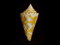
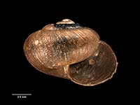
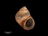
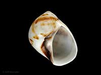
Images: Conasprella raoulensis Powell, 1958

Dredged in 64-69 metres, off White Island, Bay of Plenty, NZ. 27mm
Taxonomy
Family: CONIDAE Full Classification: Mollusca (Phylum) > Gastropoda (Class) > Caenogastropoda (Subclass) > Neogastropoda (Order) > Conoidea (Superfamily) > Conidae (Family) > Conasprella (Genus) > raoulensis (Species) Synonymised Names: =Conasprella (Endemoconus) raoulensis (Powell, 1958) accepted, alternate representation =Conus (Kermasprella) raoulensis Powell, 1958 =Conus raoulensis Powell, 1958 =Endemoconus raoulensis (Powell, 1958) |
Details: Conasprella raoulensis Powell, 1958
Distribution:
Norfolk Island and Wanganella Bank, 113-118 metres. Norfolk Ridge. Kermadec Islands 44-146 metres
Geographical Range:
KA
Notes:
Species Links
Distribution Map
References and Publications
- Puillandre, N., Duda, T.F., Meyer, C., Olivera, B.M., Bouchet, P. 2015 One, four or 100 genera? A new classification of the cone snails, Journal of Molluscan Studies, 81 (p.5)
- Filmer, R.M. Jul/2008 Conus howellii and Conus raoulensis. One or Two Species?
, The Cone Collector, 7 (p.27) - Brook, F.J., Marshall, B.A. 1998 The coastal molluscan fauna of the northern Kermadec Islands, southwest Pacific Ocean, Journal of the Royal Society of New Zealand, 28 (p.227)
- Adams, R. Oct/1995 Conilithes wollastoni, Maxwell and Cone Shells in NZ, Poirieria, 17(4) (p.8)
- Marshall, B.A. 1981 New records of Conidae (Mollusca: Gastropoda) from the New Zealand region, New Zealand Journal of Zoology, 8(4) (p.495)
Key to Geographical Ranges

The symbols K.A.C.F.M.An. are used to indicate the geographical range of the species.
They have been adopted to give an approximation of the range of each species within New Zealand.
K=
Kermadec Islands
A=
Aupourian - Kaipara Harbour, north around North Cape, encompassing the Three Kings Islands and south to East Cape
C=
Cookian - Lower North Island and the northern part of the South Island
F=
Forsterian - Otago, Fiordland and Stewart Island
M=
Moriorian - Chatham Islands, Pitt Island
An=
Antipodean - Subantarctic Islands of New Zealand
Fw =
Freshwater
L =
Land
N =
North Island
S =
South Island
R =
Recent
Sf =
Subfossil
Fo =
Fossil
Compare Species (
/6)