Compare Mammilla simiae
| toggle to add to compare list |
Taxonomy
Family: Subfamily: NATICIDAE: POLINICINAE Full Classification: Mollusca (Phylum) > Gastropoda (Class) > Caenogastropoda (Subclass) > Littorinimorpha (Order) > Naticoidea (Superfamily) > Naticidae (Family) > Polinicinae (Subfamily) > Mammilla (Genus) > simiae (Species) Synonymised Names: =Mamilla simiae (Deshayes, 1838) =Mammilla propesimiae Iredale, 1929 =Natica samarensis Récluz, 1844 =Natica sigaretina Menke, 1828 =Natica simiae Deshayes, 1838 =Polinices (Mammilla) simiae (Deshayes, 1838) =Polinices simiae (Deshayes, 1838) |
Images: Mammilla simiae (Deshayes, 1838)

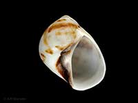
Washed up on the Northland east coast, NZ. 25mm

Washed up on the Northland east coast, NZ. 25mm

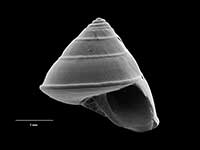
On sand flats Parengarenga Harbour, Far North, NZ

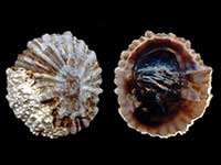
Washed up in beach drift, Rarawa Beach, Far North, NZ

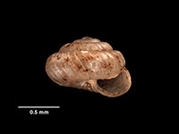
Washed up in shell drift, Rarawa, Far North, NZ. 19mm
Taxonomy
Family: Subfamily: NATICIDAE: POLINICINAE Full Classification: Mollusca (Phylum) > Gastropoda (Class) > Caenogastropoda (Subclass) > Littorinimorpha (Order) > Naticoidea (Superfamily) > Naticidae (Family) > Polinicinae (Subfamily) > Mammilla (Genus) > simiae (Species) Synonymised Names: =Mamilla simiae (Deshayes, 1838) =Mammilla propesimiae Iredale, 1929 =Natica samarensis Récluz, 1844 =Natica sigaretina Menke, 1828 =Natica simiae Deshayes, 1838 =Polinices (Mammilla) simiae (Deshayes, 1838) =Polinices simiae (Deshayes, 1838) |
Details: Mammilla simiae (Deshayes, 1838)
Size/Grows to:
Height 36mm, Width 30mm
Distribution:
Northland to East Cape. Also Kermadec and Norfolk Islands. In beach drift and alive from low tide
Geographical Range:
KA
Notes:
Species Links
Distribution Map
References and Publications
- Raven, J.L. Nov/2011 Notes on New Zealand collected species, Cookia, 23 (p.18)
- Brook, F.J., Marshall, B.A. 1998 The coastal molluscan fauna of the northern Kermadec Islands, southwest Pacific Ocean, Journal of the Royal Society of New Zealand, 28 (p.220)
- Powell, A.W.B. 1979 New Zealand Mollusca: Marine, Land and Freshwater Shells, Collins, Auckland (p.156)
- Powell, A.W.B. 1934 Gastropods new to the New Zealand Fauna; with descriptions of six new Species and a new Subspecies, Transactions and Proceedings of the Royal Society of New Zealand, 64 (p.156)
- Oliver, W.R.B. 1915 The Mollusca of the Kermadec Islands, Transactions and Proceedings of the New Zealand Institute, 47 (p.524)
*98 © Museum of New Zealand Te Papa Tongarewa (CC-BY-NC-ND)
Key to Geographical Ranges

The symbols K.A.C.F.M.An. are used to indicate the geographical range of the species.
They have been adopted to give an approximation of the range of each species within New Zealand.
K=
Kermadec Islands
A=
Aupourian - Kaipara Harbour, north around North Cape, encompassing the Three Kings Islands and south to East Cape
C=
Cookian - Lower North Island and the northern part of the South Island
F=
Forsterian - Otago, Fiordland and Stewart Island
M=
Moriorian - Chatham Islands, Pitt Island
An=
Antipodean - Subantarctic Islands of New Zealand
Fw =
Freshwater
L =
Land
N =
North Island
S =
South Island
R =
Recent
Sf =
Subfossil
Fo =
Fossil
Compare Species (
/6)