Compare Roseaplagis mortenseni
| toggle to add to compare list |
Taxonomy
Family: Subfamily: TROCHIDAE: CANTHARIDINAE Full Classification: Mollusca (Phylum) > Gastropoda (Class) > Vetigastropoda (Subclass) > Trochida (Order) > Trochoidea (Superfamily) > Trochidae (Family) > Cantharidinae (Subfamily) > Roseaplagis (Genus) > mortenseni (Species) Synonymised Names: =Cantharidus mortenseni (Odhner, 1924) =Gibbula mortenseni Odhner, 1924 =Micrelenchus (Plumbelenchus) mortenseni (Odhner, 1924) =Micrelenchus caelatus archibenthicola Dell, 1956 =Micrelenchus mortenseni (Odhner, 1924) =Micrelenchus sanguineus morioria Powell, 1933 |
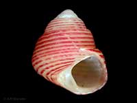
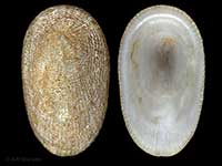
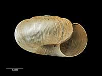
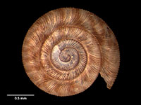
Images: Roseaplagis mortenseni (Odhner, 1924)

In beach drift, Chatham Islands, NZ. 6mm

In beach drift, Chatham Islands, NZ. 6mm

In beach drift, Chatham Islands, NZ. 5mm

In beach drift, Chatham Islands, NZ. 5mm

Holotype of Micrelenchus sanguineus morioria, collected Feb 1933, off Owenga Beach, Chatham Islands, NZ (MA70471). ~5mm. © Auckland Museum (CC-BY)
Taxonomy
Family: Subfamily: TROCHIDAE: CANTHARIDINAE Full Classification: Mollusca (Phylum) > Gastropoda (Class) > Vetigastropoda (Subclass) > Trochida (Order) > Trochoidea (Superfamily) > Trochidae (Family) > Cantharidinae (Subfamily) > Roseaplagis (Genus) > mortenseni (Species) Synonymised Names: =Cantharidus mortenseni (Odhner, 1924) =Gibbula mortenseni Odhner, 1924 =Micrelenchus (Plumbelenchus) mortenseni (Odhner, 1924) =Micrelenchus caelatus archibenthicola Dell, 1956 =Micrelenchus mortenseni (Odhner, 1924) =Micrelenchus sanguineus morioria Powell, 1933 |
Details: Roseaplagis mortenseni (Odhner, 1924)
Size/Grows to:
Height 7mm, Width 6mm
Distribution:
South Island. From Otago south to Stewart Island. Chatham, Auckland, Campbell, Antipodes and Bounty Islands. In beach drift. Living at 10-244 metres
Geographical Range:
CFMAn
Notes:
Species Links
Distribution Map
References and Publications
- Donald, K.M., Spencer, H.G. 2016 Phylogeographic patterns in New Zealand and temperate Australian cantharidines (Mollusca: Gastropoda: Trochidae: Cantharidinae): Trans-Tasman divergences are ancient, Molecular Phylogenetics and Evolution, 100 (p.341)
- Marshall, B.A. 1998 The New Zealand Recent species of Cantharidus Montfort, 1810 and Micrelenchus Finlay, 1926 (Mollusca: Gastropoda: Trochidae), Molluscan Research, 19 (p.144)
- Powell, A.W.B. 1979 New Zealand Mollusca: Marine, Land and Freshwater Shells, Collins, Auckland (p.56)
- Odhner, N.H. 1924 Papers from Dr. Th. Mortensen's Pacific Expedition 1914–1916. XIX. New Zealand Mollusca, Videnskabelige Meddelelser fra Dansk Naturhistorisk Forening i Kjobenhavn, 77 (p.14) Original Description
*98 © Museum of New Zealand Te Papa Tongarewa (CC-BY-NC-ND)
Key to Geographical Ranges

The symbols K.A.C.F.M.An. are used to indicate the geographical range of the species.
They have been adopted to give an approximation of the range of each species within New Zealand.
K=
Kermadec Islands
A=
Aupourian - Kaipara Harbour, north around North Cape, encompassing the Three Kings Islands and south to East Cape
C=
Cookian - Lower North Island and the northern part of the South Island
F=
Forsterian - Otago, Fiordland and Stewart Island
M=
Moriorian - Chatham Islands, Pitt Island
An=
Antipodean - Subantarctic Islands of New Zealand
Fw =
Freshwater
L =
Land
N =
North Island
S =
South Island
R =
Recent
Sf =
Subfossil
Fo =
Fossil
Compare Species (
/6)