Compare Tubuaia raoulensis
| toggle to add to compare list |
Taxonomy
Family: Subfamily: ACHATINELLIDAE: ELASMATININAE Full Classification: Mollusca (Phylum) > Gastropoda (Class) > Heterobranchia (Subclass) > Euthyneura (Infraclass) > Tectipleura (Subterclass) > Eupulmonata (Superorder) > Stylommatophora (Order) > Helicina (Suborder) > Pupilloidei (Infraorder) > Pupilloidea (Superfamily) > Achatinellidae (Family) > Elasmatininae (Subfamily) > Tubuaia (Genus) > raoulensis (Species) Synonymised Names: =Tornatellina kermadecensis Pilsbry & C.M. Cooke, 1915 =Tornatellina raoulensis Pilsbry & C.M. Cooke, 1915 |
Images: Tubuaia raoulensis (Pilsbry & Cooke, 1915)

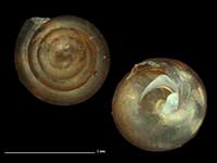
Collected 2009, Raoul Island, Kermadec Islands, NZ. 1.5mm. Reproduced courtesy of Dave Roscoe

Collected 2009, Raoul Island, Kermadec Islands, NZ. 1.5mm. Reproduced courtesy of Dave Roscoe

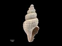
Collected 27 Oct 2007, Coral Bay, Raoul Island, Kermadec Islands, NZ. 3.1mm. Reproduced courtesy of Dave Roscoe

Collected 27 Oct 2007, Coral Bay, Raoul Island, Kermadec Islands, NZ. 3.1mm. Reproduced courtesy of Dave Roscoe
Taxonomy
Family: Subfamily: ACHATINELLIDAE: ELASMATININAE Full Classification: Mollusca (Phylum) > Gastropoda (Class) > Heterobranchia (Subclass) > Euthyneura (Infraclass) > Tectipleura (Subterclass) > Eupulmonata (Superorder) > Stylommatophora (Order) > Helicina (Suborder) > Pupilloidei (Infraorder) > Pupilloidea (Superfamily) > Achatinellidae (Family) > Elasmatininae (Subfamily) > Tubuaia (Genus) > raoulensis (Species) Synonymised Names: =Tornatellina kermadecensis Pilsbry & C.M. Cooke, 1915 =Tornatellina raoulensis Pilsbry & C.M. Cooke, 1915 |
Details: Tubuaia raoulensis (Pilsbry & Cooke, 1915)
Size/Grows to:
Height 3.1mm
Distribution:
Kermadec Islands
Geographical Range:
L.
Notes:
Species Links
Distribution Map
References and Publications
- Cooke, C.M., Kondo, Y. 1960 Revision of Tornatellinidae and Achatinellidae (Gastropoda, Pulmonata), Bernice P. Bishop Muesum Bulletin, 221 (p.156)
Key to Geographical Ranges

The symbols K.A.C.F.M.An. are used to indicate the geographical range of the species.
They have been adopted to give an approximation of the range of each species within New Zealand.
K=
Kermadec Islands
A=
Aupourian - Kaipara Harbour, north around North Cape, encompassing the Three Kings Islands and south to East Cape
C=
Cookian - Lower North Island and the northern part of the South Island
F=
Forsterian - Otago, Fiordland and Stewart Island
M=
Moriorian - Chatham Islands, Pitt Island
An=
Antipodean - Subantarctic Islands of New Zealand
Fw =
Freshwater
L =
Land
N =
North Island
S =
South Island
R =
Recent
Sf =
Subfossil
Fo =
Fossil
Compare Species (
/6)