Compare Hirtomurex nakamurai
| toggle to add to compare list |
Taxonomy
Family: Subfamily: MURICIDAE: CORALLIOPHILINAE Full Classification: Mollusca (Phylum) > Gastropoda (Class) > Caenogastropoda (Subclass) > Neogastropoda (Order) > Muricoidea (Superfamily) > Muricidae (Family) > Coralliophilinae (Subfamily) > Hirtomurex (Genus) > nakamurai (Species) |
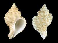
Images: Hirtomurex nakamurai Kosuge, 1985

Collected in 430-455 metres, 15 miles E of Seal Rock, NSW, Australia (C.150063). Australian Museum, Sydney
Taxonomy
Family: Subfamily: MURICIDAE: CORALLIOPHILINAE Full Classification: Mollusca (Phylum) > Gastropoda (Class) > Caenogastropoda (Subclass) > Neogastropoda (Order) > Muricoidea (Superfamily) > Muricidae (Family) > Coralliophilinae (Subfamily) > Hirtomurex (Genus) > nakamurai (Species) |
Details: Hirtomurex nakamurai Kosuge, 1985
Size/Grows to:
Height 38mm, Width 23mm
Distribution:
Japan and Australia. Southern Norfolk Ridge, NW of Cape Reinga, Far North, 514-540 metres
Geographical Range:
A
Notes:
Species Links
Distribution Map
References and Publications
- Marshall, B.A., Oliverio, M. 2009 The Recent Coralliophilinae of the New Zealand region, with descriptions of two new species (Gastropoda: Neogastropoda: Muricidae), Molluscan Research, 29(3) (p.164)
- Kosuge, S. 1985 Descriptions of four new species of the family Coralliophilidae of the Teramachi collection deposited in Toba Aquarium, Japan (Gastropoda Muricacea), Bulletin of the Institute of Malacology, Tokyo, 2 (p.45) Original Description
*98 © Museum of New Zealand Te Papa Tongarewa (CC-BY-NC-ND)
Key to Geographical Ranges

The symbols K.A.C.F.M.An. are used to indicate the geographical range of the species.
They have been adopted to give an approximation of the range of each species within New Zealand.
K=
Kermadec Islands
A=
Aupourian - Kaipara Harbour, north around North Cape, encompassing the Three Kings Islands and south to East Cape
C=
Cookian - Lower North Island and the northern part of the South Island
F=
Forsterian - Otago, Fiordland and Stewart Island
M=
Moriorian - Chatham Islands, Pitt Island
An=
Antipodean - Subantarctic Islands of New Zealand
Fw =
Freshwater
L =
Land
N =
North Island
S =
South Island
R =
Recent
Sf =
Subfossil
Fo =
Fossil
Compare Species (
/6)