Compare Alcithoe tigrina
| toggle to add to compare list |
Taxonomy
Family: Subfamily: VOLUTIDAE: CYMBIINAE Full Classification: Genus Synonyms: =Alcithoe (Leporemax) Iredale, 1937 =Gilvostia Iredale, 1937 =Leporemax Iredale, 1937 =Pachymelon (Palomelon) Finlay, 1926 =Palomelon Finlay, 1926 =Voluta (Alcithoe) H. & A. Adams, 1853 =Waihaoia (Palomelon) Finlay, 1926 =Waihaoia (Teremelon) Marwick, 1926 Synonymised Names: =Alcithoe larochei tigrina Bail & Limpus, 2005 |
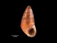
Images: Alcithoe tigrina Bail & Limpus, 2005

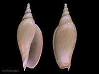
Dredged in the Bay of Plenty, 400-600 metres. 113mm
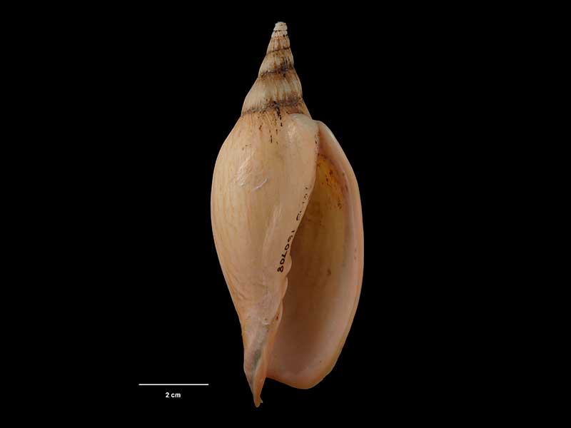
holotype of Alcithoe larochei tigrina, collected Nov 1987, SE of Mayor Island, Bay of Plenty, NZ (M.160708). ~115mm. © Museum of New Zealand Te Papa Tongarewa (CC-BY-NC-ND)
Taxonomy
Family: Subfamily: VOLUTIDAE: CYMBIINAE Full Classification: Genus Synonyms: =Alcithoe (Leporemax) Iredale, 1937 =Gilvostia Iredale, 1937 =Leporemax Iredale, 1937 =Pachymelon (Palomelon) Finlay, 1926 =Palomelon Finlay, 1926 =Voluta (Alcithoe) H. & A. Adams, 1853 =Waihaoia (Palomelon) Finlay, 1926 =Waihaoia (Teremelon) Marwick, 1926 Synonymised Names: =Alcithoe larochei tigrina Bail & Limpus, 2005 |
Details: Alcithoe tigrina Bail & Limpus, 2005
Size/Grows to:
Height 140mm, Width 64mm
Distribution:
Bay of Plenty to Mahia. Trawled around 100-600 metres
Geographical Range:
A
Notes:
Species Links
Distribution Map
References and Publications
- Hills, S.F.K., Trewick, S.A., Morgan-Richards, M. 2011 Phylogenetic information of genes, illustrated with mitochondrial data from a genus of gastropod molluscs, Biological Journal of the Linnean Society, 104 (p.783)
- Bail, P., Limpus, A. 2005 A Conchological Iconography 11, The Recent Volutes of New Zealand, with a revision of the genus Alcithoe H. & A. Adams, 1853, ConchBooks, Hackenheim, Germany (p.45) Original Description
Key to Geographical Ranges

The symbols K.A.C.F.M.An. are used to indicate the geographical range of the species.
They have been adopted to give an approximation of the range of each species within New Zealand.
K=
Kermadec Islands
A=
Aupourian - Kaipara Harbour, north around North Cape, encompassing the Three Kings Islands and south to East Cape
C=
Cookian - Lower North Island and the northern part of the South Island
F=
Forsterian - Otago, Fiordland and Stewart Island
M=
Moriorian - Chatham Islands, Pitt Island
An=
Antipodean - Subantarctic Islands of New Zealand
Fw =
Freshwater
L =
Land
N =
North Island
S =
South Island
R =
Recent
Sf =
Subfossil
Fo =
Fossil
Compare Species (
/6)