Compare Alcithoe fissurata elegans
| toggle to add to compare list |
Taxonomy
Family: Subfamily: VOLUTIDAE: CYMBIINAE Full Classification: Genus Synonyms: =Alcithoe (Leporemax) Iredale, 1937 =Gilvostia Iredale, 1937 =Leporemax Iredale, 1937 =Pachymelon (Palomelon) Finlay, 1926 =Palomelon Finlay, 1926 =Voluta (Alcithoe) H. & A. Adams, 1853 =Waihaoia (Palomelon) Finlay, 1926 =Waihaoia (Teremelon) Marwick, 1926 |
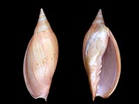
Images: Alcithoe fissurata elegans Bail & Limpus, 2005

Trawled off the Northland coast, NZ. 171mm
Taxonomy
Family: Subfamily: VOLUTIDAE: CYMBIINAE Full Classification: Genus Synonyms: =Alcithoe (Leporemax) Iredale, 1937 =Gilvostia Iredale, 1937 =Leporemax Iredale, 1937 =Pachymelon (Palomelon) Finlay, 1926 =Palomelon Finlay, 1926 =Voluta (Alcithoe) H. & A. Adams, 1853 =Waihaoia (Palomelon) Finlay, 1926 =Waihaoia (Teremelon) Marwick, 1926 |
Details: Alcithoe fissurata elegans Bail & Limpus, 2005
Size/Grows to:
Height 190mm, Width 75mm
Distribution:
Ahipara to Cape Maria van Diemen, Far North. Trawled from around 250-320 metres
Geographical Range:
A
Notes:
Species Links
Distribution Map
References and Publications
- Bail, P., Limpus, A. 2005 A Conchological Iconography 11, The Recent Volutes of New Zealand, with a revision of the genus Alcithoe H. & A. Adams, 1853, ConchBooks, Hackenheim, Germany (p.30) Original Description
Key to Geographical Ranges

The symbols K.A.C.F.M.An. are used to indicate the geographical range of the species.
They have been adopted to give an approximation of the range of each species within New Zealand.
K=
Kermadec Islands
A=
Aupourian - Kaipara Harbour, north around North Cape, encompassing the Three Kings Islands and south to East Cape
C=
Cookian - Lower North Island and the northern part of the South Island
F=
Forsterian - Otago, Fiordland and Stewart Island
M=
Moriorian - Chatham Islands, Pitt Island
An=
Antipodean - Subantarctic Islands of New Zealand
Fw =
Freshwater
L =
Land
N =
North Island
S =
South Island
R =
Recent
Sf =
Subfossil
Fo =
Fossil
Compare Species (
/6)