Compare Halopyrgus pagodulus
| toggle to add to compare list |
Taxonomy
Family: TATEIDAE Full Classification: Mollusca (Phylum) > Gastropoda (Class) > Caenogastropoda (Subclass) > Littorinimorpha (Order) > Truncatelloidea (Superfamily) > Tateidae (Family) > Halopyrgus (Genus) > pagodulus (Species) |
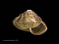
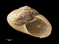
Images: Halopyrgus pagodulus Haase, 2008
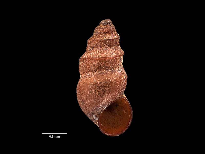
Holotype, collected 20 May 2002, E of Cape Reinga, Spirits Bay, Kapowairua, lagoon, NZ (M.174069). 2.5mm. © Museum of New Zealand Te Papa Tongarewa (CC-BY-NC-ND)
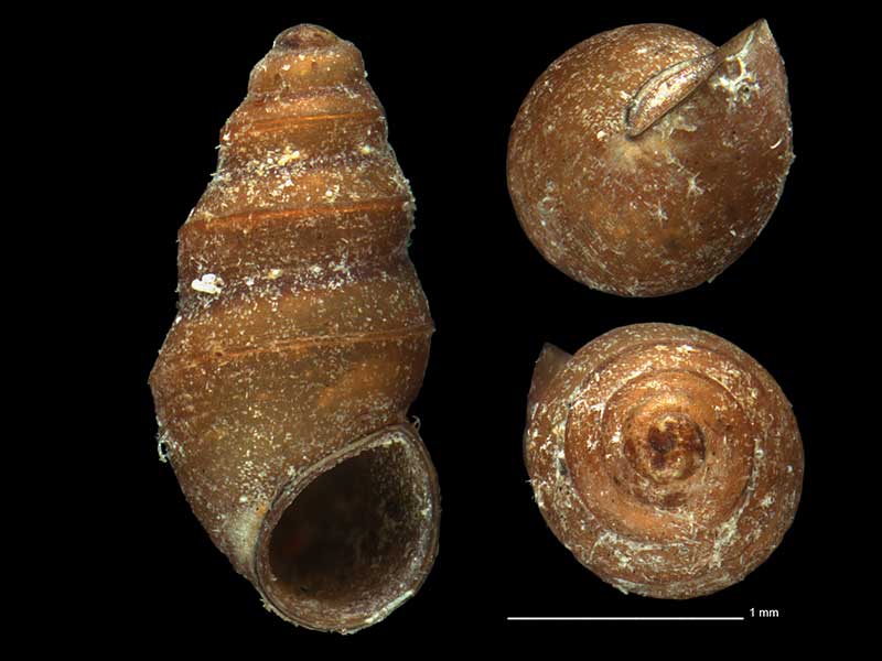
On algae on rotting logs and nearby sand in brackish tidal stream, Great Mercury Island, Bay of Plenty, NZ. 2.6mm. Reproduced courtesy of iNaturalist.nz ©openlabnz (D.J.Roscoe)
Taxonomy
Family: TATEIDAE Full Classification: Mollusca (Phylum) > Gastropoda (Class) > Caenogastropoda (Subclass) > Littorinimorpha (Order) > Truncatelloidea (Superfamily) > Tateidae (Family) > Halopyrgus (Genus) > pagodulus (Species) |
Details: Halopyrgus pagodulus Haase, 2008
Size/Grows to:
Height 2.5mm, Width 1.2mm
Distribution:
North Cape Block to northeast Northland and Great Barrier Island
Geographical Range:
Fw.N.
Notes:
Species Links
Distribution Map
References and Publications
- Haase, M. 2008 The radiation of hydrobiid gastropods in New Zealand: a revision including the description of new species based on morphology and mtDNA sequence information, Systematics and Biodiversity, 6(1) (p.109) Original Description
Key to Geographical Ranges

The symbols K.A.C.F.M.An. are used to indicate the geographical range of the species.
They have been adopted to give an approximation of the range of each species within New Zealand.
K=
Kermadec Islands
A=
Aupourian - Kaipara Harbour, north around North Cape, encompassing the Three Kings Islands and south to East Cape
C=
Cookian - Lower North Island and the northern part of the South Island
F=
Forsterian - Otago, Fiordland and Stewart Island
M=
Moriorian - Chatham Islands, Pitt Island
An=
Antipodean - Subantarctic Islands of New Zealand
Fw =
Freshwater
L =
Land
N =
North Island
S =
South Island
R =
Recent
Sf =
Subfossil
Fo =
Fossil
Compare Species (
/6)