Compare Dosinia maoriana
| toggle to add to compare list |
Taxonomy
Family: VENERIDAE Full Classification: Genus Synonyms: =Dosinia (Asa) Basterot, 1825 =Dosinia (Austrodosinia) Dall, 1902 =Dosinia (Fallartemis) Iredale, 1930 =Dosinia (Kereia) Marwick, 1927 =osinia (Pectunculus) da Costa, 1778 =Dosinia (Phacosoma) Jukes-Browne, 1912 Synonymised Names: =Dosinia (Pectunculus) maoriana W.R.B. Oliver, 1923 accepted, alternate representation |
Images: Dosinia maoriana W.R.B. Oliver, 1923
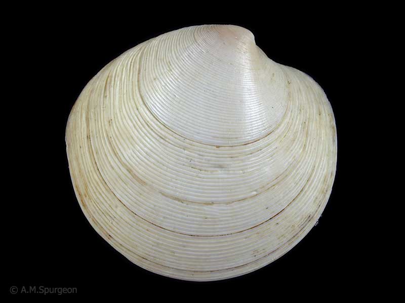
In beach drift, Bream Bay, Whangarei, Northland, NZ. 32mm
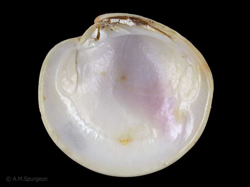
In beach drift, Bream Bay, Whangarei, Northland, NZ. 32mm
Taxonomy
Family: VENERIDAE Full Classification: Genus Synonyms: =Dosinia (Asa) Basterot, 1825 =Dosinia (Austrodosinia) Dall, 1902 =Dosinia (Fallartemis) Iredale, 1930 =Dosinia (Kereia) Marwick, 1927 =osinia (Pectunculus) da Costa, 1778 =Dosinia (Phacosoma) Jukes-Browne, 1912 Synonymised Names: =Dosinia (Pectunculus) maoriana W.R.B. Oliver, 1923 accepted, alternate representation |
Details: Dosinia maoriana W.R.B. Oliver, 1923
Size/Grows to:
Width 46mm, Height 43mm
Distribution:
Northern and south-western North Island, Chatham Islands and Mernoo Bank
Geographical Range:
ACM
Notes:
Species Links
Distribution Map
References and Publications
- Huber, M. 2010 Compendium of Bivalves 1, ConchBooks: Hackenheim, Germany (p.736)
- Powell, A.W.B. 1979 New Zealand Mollusca: Marine, Land and Freshwater Shells, Collins, Auckland (p.423)
- Oliver, W.R.B. 1923 Notes on New Zealand pelecypods, Proceedings of the Malacological Society of London, 15 (p.188) Original Description
*98 © Museum of New Zealand Te Papa Tongarewa (CC-BY-NC-ND)
Key to Geographical Ranges

The symbols K.A.C.F.M.An. are used to indicate the geographical range of the species.
They have been adopted to give an approximation of the range of each species within New Zealand.
K=
Kermadec Islands
A=
Aupourian - Kaipara Harbour, north around North Cape, encompassing the Three Kings Islands and south to East Cape
C=
Cookian - Lower North Island and the northern part of the South Island
F=
Forsterian - Otago, Fiordland and Stewart Island
M=
Moriorian - Chatham Islands, Pitt Island
An=
Antipodean - Subantarctic Islands of New Zealand
Fw =
Freshwater
L =
Land
N =
North Island
S =
South Island
R =
Recent
Sf =
Subfossil
Fo =
Fossil
Recently Viewed

Compare Species (
/6)