Compare Myllita stowei
| toggle to add to compare list |
Taxonomy
Family: LASAEIDAE Full Classification: Genus Synonyms: =Myllita (Myllitella) Finlay, 1926 accepted, alternate representation =Myllita (Zemyllita) Finlay, 1926 accepted, alternate representation =Myllitella Finlay, 1926 =Zemyllita Finlay, 1926 Synonymised Names: =Myllita (Zemyllita) stowei (Hutton, 1873) accepted, alternate representation =Pythina stowei Hutton, 1873 |
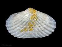
Images: Myllita stowei (Hutton, 1873)

Whangarei Heads, in shallow water. 12mm

Whangarei Heads, in shallow water. 12mm
Taxonomy
Family: LASAEIDAE Full Classification: Genus Synonyms: =Myllita (Myllitella) Finlay, 1926 accepted, alternate representation =Myllita (Zemyllita) Finlay, 1926 accepted, alternate representation =Myllitella Finlay, 1926 =Zemyllita Finlay, 1926 Synonymised Names: =Myllita (Zemyllita) stowei (Hutton, 1873) accepted, alternate representation =Pythina stowei Hutton, 1873 |
Details: Myllita stowei (Hutton, 1873)
Size/Grows to:
Width 15mm, Height 9mm
Distribution:
Three Kings Islands, North Island and northern South Island as far south as Kaikoura. Attached to the under sides of stones on sand
Geographical Range:
AC
Notes:
Species Links
Distribution Map
References and Publications
- Dawson, E.W. Nov/2003 Myllita stowei: The Mollusc and the Man - Some thoughts from Oteranga Bay, Cookia, 15 (p.47)
- Powell, A.W.B. 1979 New Zealand Mollusca: Marine, Land and Freshwater Shells, Collins, Auckland (p.392)
- Hutton, F.W. 1880 Manual of the New Zealand Mollusca, Colonial Museum & Geological Survey Department (p.157)
*98 © Museum of New Zealand Te Papa Tongarewa (CC-BY-NC-ND)
Key to Geographical Ranges

The symbols K.A.C.F.M.An. are used to indicate the geographical range of the species.
They have been adopted to give an approximation of the range of each species within New Zealand.
K=
Kermadec Islands
A=
Aupourian - Kaipara Harbour, north around North Cape, encompassing the Three Kings Islands and south to East Cape
C=
Cookian - Lower North Island and the northern part of the South Island
F=
Forsterian - Otago, Fiordland and Stewart Island
M=
Moriorian - Chatham Islands, Pitt Island
An=
Antipodean - Subantarctic Islands of New Zealand
Fw =
Freshwater
L =
Land
N =
North Island
S =
South Island
R =
Recent
Sf =
Subfossil
Fo =
Fossil
Recently Viewed
Compare Species (
/6)