Compare Tucetona laticostata
| toggle to add to compare list |
Taxonomy
Family: Subfamily: GLYCYMERIDAE: GLYCYMERINAE Full Classification: Mollusca (Phylum) > Bivalvia (Class) > Pteriomorphia (Subclass) > Arcida (Order) > Arcoidea (Superfamily) > Glycymeridae (Family) > Glycymerinae (Subfamily) > Tucetona (Genus) > laticostata (Species) Genus Synonyms: =Glycymeris (Grandaxinea) Iredale, 1931 =Glycymeris (Tucetona) Iredale, 1939 Synonymised Names: =Glycymeris magnificens Iredale, 1929 =Pectunculus laticostatus Quoy & Gaimard, 1835 =Pectunculus ovatus Quoy & Gaimard, 1835 =Pectunculus roseus Reeve, 1843 =Petunculus laticostatus Quoy & Gaimard, 1835 =Petunculus ovatus Quoy & Gaimard, 1835 |
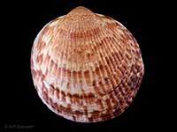
Images: Tucetona laticostata (Quoy & Gaimard, 1835)

In beach drift, Bream Bay, Northland, NZ. 64mm

In beach drift, Bream Bay, Northland, NZ. 64mm
Taxonomy
Family: Subfamily: GLYCYMERIDAE: GLYCYMERINAE Full Classification: Mollusca (Phylum) > Bivalvia (Class) > Pteriomorphia (Subclass) > Arcida (Order) > Arcoidea (Superfamily) > Glycymeridae (Family) > Glycymerinae (Subfamily) > Tucetona (Genus) > laticostata (Species) Genus Synonyms: =Glycymeris (Grandaxinea) Iredale, 1931 =Glycymeris (Tucetona) Iredale, 1939 Synonymised Names: =Glycymeris magnificens Iredale, 1929 =Pectunculus laticostatus Quoy & Gaimard, 1835 =Pectunculus ovatus Quoy & Gaimard, 1835 =Pectunculus roseus Reeve, 1843 =Petunculus laticostatus Quoy & Gaimard, 1835 =Petunculus ovatus Quoy & Gaimard, 1835 |
Details: Tucetona laticostata (Quoy & Gaimard, 1835)
Size/Grows to:
Height 124mm, Width 110mm
Distribution:
Middlesex and King Banks, Three Kings Islands, off Cape Reinga, North Island, far northern and far southern South Island, Stewart, Snares and Chatham Islands, and Mernoo Bank. In shallow water to about 75 metres
Geographical Range:
ACFMAn
Notes:
Species Links
Distribution Map
References and Publications
- Powell, A.W.B. 1979 New Zealand Mollusca: Marine, Land and Freshwater Shells, Collins, Auckland (p.365)
*98 © Museum of New Zealand Te Papa Tongarewa (CC-BY-NC-ND)
Key to Geographical Ranges

The symbols K.A.C.F.M.An. are used to indicate the geographical range of the species.
They have been adopted to give an approximation of the range of each species within New Zealand.
K=
Kermadec Islands
A=
Aupourian - Kaipara Harbour, north around North Cape, encompassing the Three Kings Islands and south to East Cape
C=
Cookian - Lower North Island and the northern part of the South Island
F=
Forsterian - Otago, Fiordland and Stewart Island
M=
Moriorian - Chatham Islands, Pitt Island
An=
Antipodean - Subantarctic Islands of New Zealand
Fw =
Freshwater
L =
Land
N =
North Island
S =
South Island
R =
Recent
Sf =
Subfossil
Fo =
Fossil
Recently Viewed
Compare Species (
/6)