Compare Amborhytida duplicata
| toggle to add to compare list |
Taxonomy
Family: Subfamily: RHYTIDIDAE: RHYTIDINAE Full Classification: Mollusca (Phylum) > Gastropoda (Class) > Heterobranchia (Subclass) > Euthyneura (Infraclass) > Tectipleura (Subterclass) > Eupulmonata (Superorder) > Stylommatophora (Order) > Helicina (Suborder) > Rhytidoidei (Infraorder) > Rhytidoidea (Superfamily) > Rhytididae (Family) > Rhytidinae (Subfamily) > Amborhytida (Genus) > duplicata (Species) Synonymised Names: =Rhytida duplicata Suter, 1904 (original combination) =Rhytida duplicata vivens Powell, 1936 |
Images: Amborhytida duplicata (Suter, 1904)
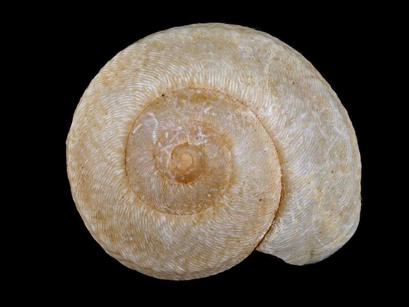
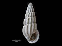
Far North. Sub-fossil in sand dunes. 26mm

Far North. Sub-fossil in sand dunes. 26mm

Far North. Sub-fossil in sand dunes. 26mm

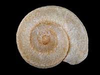
Far North, living in patches of bush. 21mm

Far North, living in patches of bush. 21mm

Far North, living in patches of bush. 21mm

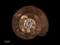
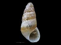
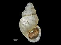
Holotype of Rhytida duplicata vivens Powell, 1946, collected Feb 1932, Mt. Unuwhao, Far North, NZ (MA71106). © Auckland Museum (CC-BY)

Holotype of Rhytida duplicata vivens Powell, 1946, collected Feb 1932, Mt. Unuwhao, Far North, NZ (MA71106). © Auckland Museum (CC-BY)

Holotype of Rhytida duplicata vivens Powell, 1946, collected Feb 1932, Mt. Unuwhao, Far North, NZ (MA71106). © Auckland Museum (CC-BY)
Taxonomy
Family: Subfamily: RHYTIDIDAE: RHYTIDINAE Full Classification: Mollusca (Phylum) > Gastropoda (Class) > Heterobranchia (Subclass) > Euthyneura (Infraclass) > Tectipleura (Subterclass) > Eupulmonata (Superorder) > Stylommatophora (Order) > Helicina (Suborder) > Rhytidoidei (Infraorder) > Rhytidoidea (Superfamily) > Rhytididae (Family) > Rhytidinae (Subfamily) > Amborhytida (Genus) > duplicata (Species) Synonymised Names: =Rhytida duplicata Suter, 1904 (original combination) =Rhytida duplicata vivens Powell, 1936 |
Details: Amborhytida duplicata (Suter, 1904)
Size/Grows to:
Length 26mm, Height 15mm
Distribution:
North Cape block to Cape Maria van Diemen
Geographical Range:
L.N.R.Sf.
Notes:
Species Links
Distribution Map
References and Publications
- Goulstone, J.F., Mayhill, P.C., Parrish, G.R. 1993 An Illustrated Guide to the Land Mollusca of the Te Paki ecological region, Northland, New Zealand, New Zealand Journal of Zoology, 34 (p.7)
- Powell, A.W.B. 1979 New Zealand Mollusca: Marine, Land and Freshwater Shells, Collins, Auckland (p.346)
- Suter, H. 1904 New land-shells from New Zealand., Proceedings of the Malacological Society of London, 6 (p.155) Original Description
Key to Geographical Ranges

The symbols K.A.C.F.M.An. are used to indicate the geographical range of the species.
They have been adopted to give an approximation of the range of each species within New Zealand.
K=
Kermadec Islands
A=
Aupourian - Kaipara Harbour, north around North Cape, encompassing the Three Kings Islands and south to East Cape
C=
Cookian - Lower North Island and the northern part of the South Island
F=
Forsterian - Otago, Fiordland and Stewart Island
M=
Moriorian - Chatham Islands, Pitt Island
An=
Antipodean - Subantarctic Islands of New Zealand
Fw =
Freshwater
L =
Land
N =
North Island
S =
South Island
R =
Recent
Sf =
Subfossil
Fo =
Fossil
Compare Species (
/6)