Compare Distorsionella lewisi
| toggle to add to compare list |
Taxonomy
Family: THALASSOCYONIDAE Full Classification: Mollusca (Phylum) > Gastropoda (Class) > Caenogastropoda (Subclass) > Littorinimorpha (Order) > Tonnoidea (Superfamily) > Thalassocyonidae (Family) > Distorsionella (Genus) > lewisi (Species) Genus Synonyms: =Distorsio (Distorsionella) Beu, 1978 Synonymised Names: =Distorsio (Distorsionella) lewisi Beu, 1978 =Distorsionella beui F. Riedel, 2000 =Personopsis ednafarinasi Parth, 2006 |
Images: Distorsionella lewisi (Beu, 1978)
No images yet of this species.
If you have good photos you would like to share, please email me, and I can add them here.
If you have good photos you would like to share, please email me, and I can add them here.
Taxonomy
Family: THALASSOCYONIDAE Full Classification: Mollusca (Phylum) > Gastropoda (Class) > Caenogastropoda (Subclass) > Littorinimorpha (Order) > Tonnoidea (Superfamily) > Thalassocyonidae (Family) > Distorsionella (Genus) > lewisi (Species) Genus Synonyms: =Distorsio (Distorsionella) Beu, 1978 Synonymised Names: =Distorsio (Distorsionella) lewisi Beu, 1978 =Distorsionella beui F. Riedel, 2000 =Personopsis ednafarinasi Parth, 2006 |
Details: Distorsionella lewisi (Beu, 1978)
Size/Grows to:
Height 57mm
Distribution:
N Challenger Plateau to Wanganella Bank, to Kermadec Islands, Northern NZ
Geographical Range:
KA
Notes:
Species Links
Distribution Map
References and Publications
- Warén, A., Bouchet, P. 1990 Laubierinidae and Pisanianurinae (Ranellidae), two new deep-sea taxa of the Tonnoidea (Gastropoda: Prosobranchia), The Veliger, 33(1) (p.96)
- Beu, A.G. 1978 New records and species of Cymatiidae (Gastropoda: Prosobranchia) from the Kermadec Islands, Norfolk Ridge and New Zealand, Journal of the Malacological Society of Australia, 4(1) (p.38) Original Description
*98 © Museum of New Zealand Te Papa Tongarewa (CC-BY-NC-ND)
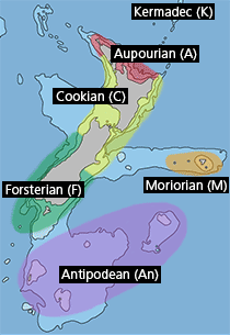
Key to Geographical Ranges

The symbols K.A.C.F.M.An. are used to indicate the geographical range of the species.
They have been adopted to give an approximation of the range of each species within New Zealand.
K=
Kermadec Islands
A=
Aupourian - Kaipara Harbour, north around North Cape, encompassing the Three Kings Islands and south to East Cape
C=
Cookian - Lower North Island and the northern part of the South Island
F=
Forsterian - Otago, Fiordland and Stewart Island
M=
Moriorian - Chatham Islands, Pitt Island
An=
Antipodean - Subantarctic Islands of New Zealand
Fw =
Freshwater
L =
Land
N =
North Island
S =
South Island
R =
Recent
Sf =
Subfossil
Fo =
Fossil
