Compare Struthiolaria papulosa
| toggle to add to compare list |
Taxonomy
Family: STRUTHIOLARIIDAE Full Classification: Mollusca (Phylum) > Gastropoda (Class) > Caenogastropoda (Subclass) > Littorinimorpha (Order) > Stromboidea (Superfamily) > Struthiolariidae (Family) > Struthiolaria (Genus) > papulosa (Species) Synonymised Names: =Buccinum coronarium Lightfoot, 1786 =Buccinum papulosum Martyn, 1784 =Murex stramineus Gmelin, 1791 =Struthiolaria (Struthiolaria) papulosa (Martyn, 1784) =Struthiolaria gigas G.B. Sowerby II, 1842 =Struthiolaria nodosa Gray, 1835 =Struthiolaria nodulosa Lamarck, 1816 =Struthiolaria papillaris Gray, 1857 =Struthiolaria sulcata Jonas, 1839 =Struthiolaria tasmani L.C. King, 1933 |
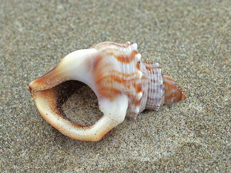
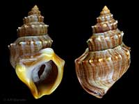
Images: Struthiolaria papulosa (Martyn, 1784)
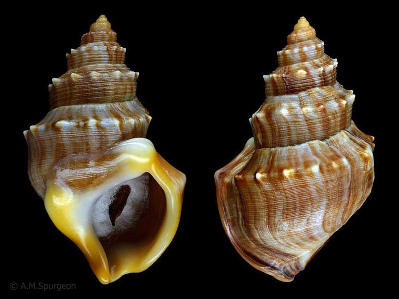
In beach drift, Bream Bay, Whangarei, NZ. 72mm
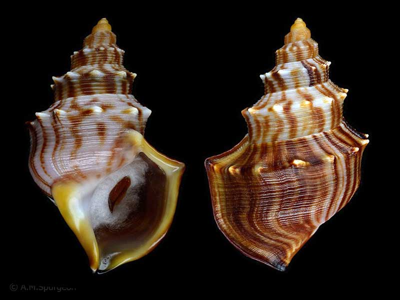
In beach drift, Bream Bay, Whangarei, NZ. Showing thinner immature lip. 65mm
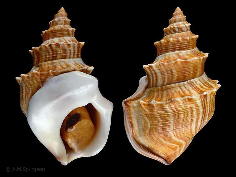
Manukau Harbour, Auckland, NZ. 81mm
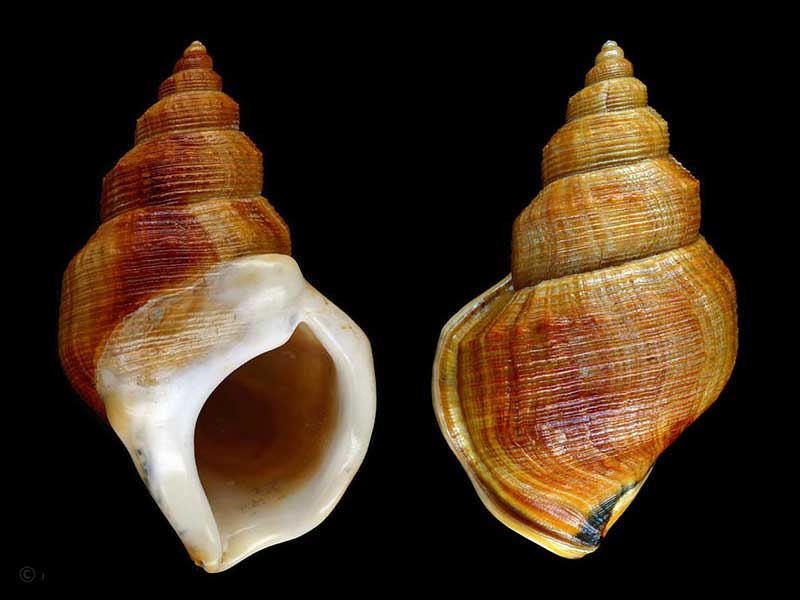
(gigas form) - Off Taiaroa Head, Otago, NZ. 87mm
From Ruakaka, south of Whangarei, Northland, NZ
Taxonomy
Family: STRUTHIOLARIIDAE Full Classification: Mollusca (Phylum) > Gastropoda (Class) > Caenogastropoda (Subclass) > Littorinimorpha (Order) > Stromboidea (Superfamily) > Struthiolariidae (Family) > Struthiolaria (Genus) > papulosa (Species) Synonymised Names: =Buccinum coronarium Lightfoot, 1786 =Buccinum papulosum Martyn, 1784 =Murex stramineus Gmelin, 1791 =Struthiolaria (Struthiolaria) papulosa (Martyn, 1784) =Struthiolaria gigas G.B. Sowerby II, 1842 =Struthiolaria nodosa Gray, 1835 =Struthiolaria nodulosa Lamarck, 1816 =Struthiolaria papillaris Gray, 1857 =Struthiolaria sulcata Jonas, 1839 =Struthiolaria tasmani L.C. King, 1933 |
Details: Struthiolaria papulosa (Martyn, 1784)
Size/Grows to:
Height 106mm, Width 63mm
Distribution:
North, South and Stewart Island. In shallow water, on sand flats in sheltered to open coasts
Geographical Range:
ACF
Notes:
Species Links
Distribution Map
References and Publications
- Mienis, H.K. Nov/1998 A Blister Pearl in Struthiolaria papulosa, Poirieria, 23 (p.6)
- Morton, J.E. Apr/1997 The Strombacea Re-visited Part 1, Strithiolaria and Aporrhais, Poirieria, 20 (p.1)
- Powell, A.W.B. 1979 New Zealand Mollusca: Marine, Land and Freshwater Shells, Collins, Auckland (p.142)
- Martyn, T. 1784 The universal conchologist, exhibiting the figure of every known shells 1-4, vol 1-4 Original Description
*98 © Museum of New Zealand Te Papa Tongarewa (CC-BY-NC-ND)
Key to Geographical Ranges

The symbols K.A.C.F.M.An. are used to indicate the geographical range of the species.
They have been adopted to give an approximation of the range of each species within New Zealand.
K=
Kermadec Islands
A=
Aupourian - Kaipara Harbour, north around North Cape, encompassing the Three Kings Islands and south to East Cape
C=
Cookian - Lower North Island and the northern part of the South Island
F=
Forsterian - Otago, Fiordland and Stewart Island
M=
Moriorian - Chatham Islands, Pitt Island
An=
Antipodean - Subantarctic Islands of New Zealand
Fw =
Freshwater
L =
Land
N =
North Island
S =
South Island
R =
Recent
Sf =
Subfossil
Fo =
Fossil
Compare Species (
/6)