Compare Pseudestea crassiconus
| toggle to add to compare list |
Taxonomy
Family: ANABATHRIDAE Full Classification: Mollusca (Phylum) > Gastropoda (Class) > Caenogastropoda (Subclass) > Littorinimorpha (Order) > Truncatelloidea (Superfamily) > Anabathridae (Family) > Pseudestea (Genus) > crassiconus (Species) Synonymised Names: =Scrobs crassiconus Powell, 1933 |
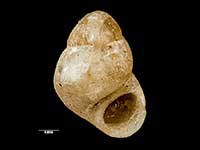
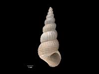
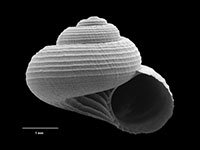
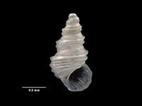
Images: Pseudestea crassiconus (Powell, 1933)

Holotype, collected in Jan 1924, Tryphena Bay, Great Barrier Island, Hauraki Gulf, NZ (MA72134). © Auckland Museum (CC-BY)
Taxonomy
Family: ANABATHRIDAE Full Classification: Mollusca (Phylum) > Gastropoda (Class) > Caenogastropoda (Subclass) > Littorinimorpha (Order) > Truncatelloidea (Superfamily) > Anabathridae (Family) > Pseudestea (Genus) > crassiconus (Species) Synonymised Names: =Scrobs crassiconus Powell, 1933 |
Details: Pseudestea crassiconus (Powell, 1933)
Size/Grows to:
Height 1.26mm, Width 0.98mm
Distribution:
Off Three Kings Islands and Northland
Geographical Range:
A
Notes:
Species Links
Distribution Map
References and Publications
- Ponder, W.F. 1983 Review of the genera of the Barleeidae (Mollusca: Gastropoda: Rissoacea), Records of the Australian Museum, 35 (p.255)
- Powell, A.W.B. 1979 New Zealand Mollusca: Marine, Land and Freshwater Shells, Collins, Auckland (p.104)
- Powell, A.W.B. 1933 On five new species of recent New Zealand Mollusca, Proceedings of the Malacological Society of London, 20(5) (p.196) Original Description
*98 © Museum of New Zealand Te Papa Tongarewa (CC-BY-NC-ND)
Key to Geographical Ranges

The symbols K.A.C.F.M.An. are used to indicate the geographical range of the species.
They have been adopted to give an approximation of the range of each species within New Zealand.
K=
Kermadec Islands
A=
Aupourian - Kaipara Harbour, north around North Cape, encompassing the Three Kings Islands and south to East Cape
C=
Cookian - Lower North Island and the northern part of the South Island
F=
Forsterian - Otago, Fiordland and Stewart Island
M=
Moriorian - Chatham Islands, Pitt Island
An=
Antipodean - Subantarctic Islands of New Zealand
Fw =
Freshwater
L =
Land
N =
North Island
S =
South Island
R =
Recent
Sf =
Subfossil
Fo =
Fossil
Compare Species (
/6)