Compare Pisinna subfusca
| toggle to add to compare list |
Taxonomy
Family: ANABATHRIDAE Full Classification: Mollusca (Phylum) > Gastropoda (Class) > Caenogastropoda (Subclass) > Littorinimorpha (Order) > Truncatelloidea (Superfamily) > Anabathridae (Family) > Pisinna (Genus) > subfusca (Species) Genus Synonyms: =Estea Iredale, 1915 =Estea (Microestea) Ponder, 1965 =Feldestea Iredale, 1955 =Hagenmulleria Bourguignat, 1881 =Microestea Ponder, 1965 =Nodulestea Iredale, 1955 =Pisanna Monterosato, 1878 (misspelling) Synonymised Names: =Estea guesti Powell, 1933 =Estea subfusca (Hutton, 1873) =Estea subfusca subfusca (Hutton, 1873) =Pisinna subfusca subfusca (Hutton, 1873) accepted, alternate representation =Rissoa subfusca Hutton, 1873 =Rissoia (Cingula) subfusca (Hutton, 1873) =Rissoia subfusca (Hutton, 1873) |
Images: Pisinna subfusca (Hutton, 1873)

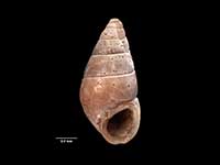
Holotype of Rissoa subfusca, collected no other data, NZ (M.000148). ~2.8mm. © Museum of New Zealand Te Papa Tongarewa (CC-BY-NC-ND)

Holotype, collected Feb 1933, Waitangi, Chatham Islands, NZ (MA70277). © Auckland Museum (CC-BY)
Taxonomy
Family: ANABATHRIDAE Full Classification: Mollusca (Phylum) > Gastropoda (Class) > Caenogastropoda (Subclass) > Littorinimorpha (Order) > Truncatelloidea (Superfamily) > Anabathridae (Family) > Pisinna (Genus) > subfusca (Species) Genus Synonyms: =Estea Iredale, 1915 =Estea (Microestea) Ponder, 1965 =Feldestea Iredale, 1955 =Hagenmulleria Bourguignat, 1881 =Microestea Ponder, 1965 =Nodulestea Iredale, 1955 =Pisanna Monterosato, 1878 (misspelling) Synonymised Names: =Estea guesti Powell, 1933 =Estea subfusca (Hutton, 1873) =Estea subfusca subfusca (Hutton, 1873) =Pisinna subfusca subfusca (Hutton, 1873) accepted, alternate representation =Rissoa subfusca Hutton, 1873 =Rissoia (Cingula) subfusca (Hutton, 1873) =Rissoia subfusca (Hutton, 1873) |
Details: Pisinna subfusca (Hutton, 1873)
Size/Grows to:
Height 2.8mm, Width 1.4mm
Distribution:
South Islands, Stewart, Snares and Chatham Islands
Geographical Range:
CFMAn
Notes:
Species Links
Distribution Map
References and Publications
- Powell, A.W.B. 1979 New Zealand Mollusca: Marine, Land and Freshwater Shells, Collins, Auckland (p.103)
- Hutton, F.W. 1873 Catalogue of the Marine Mollusca of New Zealand, with diagnoses of the species, Dominion Museum (NZ) (p.28) Original Description
*98 © Museum of New Zealand Te Papa Tongarewa (CC-BY-NC-ND)
Key to Geographical Ranges

The symbols K.A.C.F.M.An. are used to indicate the geographical range of the species.
They have been adopted to give an approximation of the range of each species within New Zealand.
K=
Kermadec Islands
A=
Aupourian - Kaipara Harbour, north around North Cape, encompassing the Three Kings Islands and south to East Cape
C=
Cookian - Lower North Island and the northern part of the South Island
F=
Forsterian - Otago, Fiordland and Stewart Island
M=
Moriorian - Chatham Islands, Pitt Island
An=
Antipodean - Subantarctic Islands of New Zealand
Fw =
Freshwater
L =
Land
N =
North Island
S =
South Island
R =
Recent
Sf =
Subfossil
Fo =
Fossil
Recently Viewed
Compare Species (
/6)