Compare Pisinna impressa
| toggle to add to compare list |
Taxonomy
Family: ANABATHRIDAE Full Classification: Mollusca (Phylum) > Gastropoda (Class) > Caenogastropoda (Subclass) > Littorinimorpha (Order) > Truncatelloidea (Superfamily) > Anabathridae (Family) > Pisinna (Genus) > impressa (Species) Genus Synonyms: =Estea Iredale, 1915 =Estea (Microestea) Ponder, 1965 =Feldestea Iredale, 1955 =Hagenmulleria Bourguignat, 1881 =Microestea Ponder, 1965 =Nodulestea Iredale, 1955 =Pisanna Monterosato, 1878 (misspelling) Synonymised Names: =Estea impressa (Hutton, 1885) =Estea verticostata Powell & Bartrum, 1929 =Haurakia mixta Finlay, 1924 =Pisinna olivacea impressa (Hutton, 1885) =Rissoa impressa Hutton, 1885 =Rissoina agrestis Webster, 1905 |
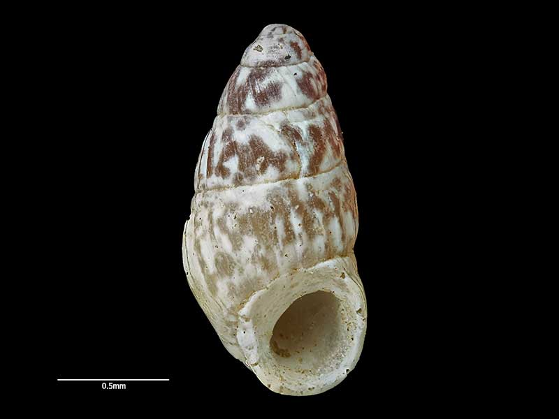
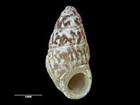
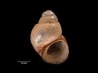
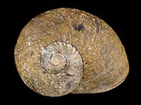
Images: Pisinna impressa (Hutton, 1885)
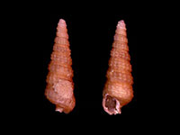
Holotype of Rissoina agrestis Webster, collected pre 1929, Takapuna Beach, Auckland, NZ (MA70672). © Auckland Museum (CC-BY)
Taxonomy
Family: ANABATHRIDAE Full Classification: Mollusca (Phylum) > Gastropoda (Class) > Caenogastropoda (Subclass) > Littorinimorpha (Order) > Truncatelloidea (Superfamily) > Anabathridae (Family) > Pisinna (Genus) > impressa (Species) Genus Synonyms: =Estea Iredale, 1915 =Estea (Microestea) Ponder, 1965 =Feldestea Iredale, 1955 =Hagenmulleria Bourguignat, 1881 =Microestea Ponder, 1965 =Nodulestea Iredale, 1955 =Pisanna Monterosato, 1878 (misspelling) Synonymised Names: =Estea impressa (Hutton, 1885) =Estea verticostata Powell & Bartrum, 1929 =Haurakia mixta Finlay, 1924 =Pisinna olivacea impressa (Hutton, 1885) =Rissoa impressa Hutton, 1885 =Rissoina agrestis Webster, 1905 |
Details: Pisinna impressa (Hutton, 1885)
Size/Grows to:
Height 2.3mm, Width 1.1mm
Distribution:
Northland to Banks Peninsula
Geographical Range:
ACM
Notes:
Species Links
Distribution Map
References and Publications
- Powell, A.W.B. 1979 New Zealand Mollusca: Marine, Land and Freshwater Shells, Collins, Auckland (p.101)
- Hutton, F.W. 1885 Descriptions of new Tertiary shells. Part 1, Transactions of the New Zealand Institute, 17 (p.321) Original Description
Key to Geographical Ranges

The symbols K.A.C.F.M.An. are used to indicate the geographical range of the species.
They have been adopted to give an approximation of the range of each species within New Zealand.
K=
Kermadec Islands
A=
Aupourian - Kaipara Harbour, north around North Cape, encompassing the Three Kings Islands and south to East Cape
C=
Cookian - Lower North Island and the northern part of the South Island
F=
Forsterian - Otago, Fiordland and Stewart Island
M=
Moriorian - Chatham Islands, Pitt Island
An=
Antipodean - Subantarctic Islands of New Zealand
Fw =
Freshwater
L =
Land
N =
North Island
S =
South Island
R =
Recent
Sf =
Subfossil
Fo =
Fossil
Compare Species (
/6)