Compare Eatoniella fuscosubucula
| toggle to add to compare list |
Taxonomy
Family: EATONIELLIDAE Full Classification: Mollusca (Phylum) > Gastropoda (Class) > Caenogastropoda (Subclass) > Littorinimorpha (Order) > Cingulopsoidea (Superfamily) > Eatoniellidae (Family) > Eatoniella (Genus) > fuscosubucula (Species) Genus Synonyms: =Cerostraca W.R.B. Oliver, 1915 =Dardania Hutton, 1882 =Dardanula Iredale, 1915 =Eatonia E.A. Smith, 1875 =Eatoniella (Abscindostoma) Ponder, 1965 =Eatoniella (Albitoniella) Ponder, 1965 =Eatoniella (Albosabula) Ponder, 1965 =Eatoniella (Caveatoniella) Ponder, 1965 =Eatoniella (Cerostraca) W.R.B. Oliver, 1915 =Eatoniella (Dardaniopsis) Ponder, 1965 =Eatoniella (Dardanula) Iredale, 1915 =Eatoniella (Eatoniella) Dall, 1876 =Eatoniella (Pellax) Finlay, 1926 =Pellax Finlay, 1926 =Rissoina (Eatoniella) Dall, 1876 Synonymised Names: =Eatoniella (Dardanula) fuscosubucula Ponder, 1965 |
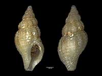
Images: Eatoniella fuscosubucula Ponder, 1965
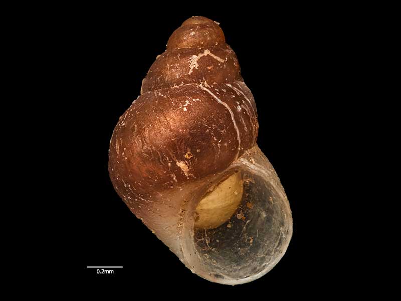
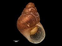
Holotype, collected in Jan 1950, Thule Bay, Paterson Inlet, Stewart Island, NZ (MA71259). © Auckland Museum (CC-BY)
Taxonomy
Family: EATONIELLIDAE Full Classification: Mollusca (Phylum) > Gastropoda (Class) > Caenogastropoda (Subclass) > Littorinimorpha (Order) > Cingulopsoidea (Superfamily) > Eatoniellidae (Family) > Eatoniella (Genus) > fuscosubucula (Species) Genus Synonyms: =Cerostraca W.R.B. Oliver, 1915 =Dardania Hutton, 1882 =Dardanula Iredale, 1915 =Eatonia E.A. Smith, 1875 =Eatoniella (Abscindostoma) Ponder, 1965 =Eatoniella (Albitoniella) Ponder, 1965 =Eatoniella (Albosabula) Ponder, 1965 =Eatoniella (Caveatoniella) Ponder, 1965 =Eatoniella (Cerostraca) W.R.B. Oliver, 1915 =Eatoniella (Dardaniopsis) Ponder, 1965 =Eatoniella (Dardanula) Iredale, 1915 =Eatoniella (Eatoniella) Dall, 1876 =Eatoniella (Pellax) Finlay, 1926 =Pellax Finlay, 1926 =Rissoina (Eatoniella) Dall, 1876 Synonymised Names: =Eatoniella (Dardanula) fuscosubucula Ponder, 1965 |
Details: Eatoniella fuscosubucula Ponder, 1965
Size/Grows to:
Height 1.4mm, Width 0.95mm
Distribution:
Southern South Island, Stewart and Auckland Islands
Geographical Range:
FAn
Notes:
Species Links
Distribution Map
References and Publications
- Powell, A.W.B. 1979 New Zealand Mollusca: Marine, Land and Freshwater Shells, Collins, Auckland (p.92)
- Ponder, W.F. 1965 The family Eatoniellidae in New Zealand, Records of the Auckland Institute and Museum, 6(2) (p.80) Original Description
Key to Geographical Ranges

The symbols K.A.C.F.M.An. are used to indicate the geographical range of the species.
They have been adopted to give an approximation of the range of each species within New Zealand.
K=
Kermadec Islands
A=
Aupourian - Kaipara Harbour, north around North Cape, encompassing the Three Kings Islands and south to East Cape
C=
Cookian - Lower North Island and the northern part of the South Island
F=
Forsterian - Otago, Fiordland and Stewart Island
M=
Moriorian - Chatham Islands, Pitt Island
An=
Antipodean - Subantarctic Islands of New Zealand
Fw =
Freshwater
L =
Land
N =
North Island
S =
South Island
R =
Recent
Sf =
Subfossil
Fo =
Fossil
Compare Species (
/6)