Compare Bruceiella laevigata
| toggle to add to compare list |
Taxonomy
Family: SKENEIDAE Full Classification: Mollusca (Phylum) > Gastropoda (Class) > Vetigastropoda (Subclass) > Trochida (Order) > Trochoidea (Superfamily) > Skeneidae (Family) > Bruceiella (Genus) > laevigata (Species) |
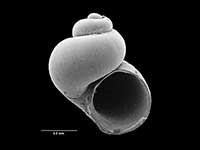
Images: Bruceiella laevigata B.A. Marshall, 1994

Holotype, collected 23 Aug 1989, NE of Chatham Islands, NZ (M.116969). 1.7mm. © Museum of New Zealand Te Papa Tongarewa (CC-BY-NC-ND)
Taxonomy
Family: SKENEIDAE Full Classification: Mollusca (Phylum) > Gastropoda (Class) > Vetigastropoda (Subclass) > Trochida (Order) > Trochoidea (Superfamily) > Skeneidae (Family) > Bruceiella (Genus) > laevigata (Species) |
Details: Bruceiella laevigata B.A. Marshall, 1994
Size/Grows to:
Height 1.7mm, Width 1.5mm
Distribution:
NE of Chatham Islands, 1242 metres on whalebone
Geographical Range:
M
Notes:
Species Links
Distribution Map
References and Publications
- Marshall, B.A. 1994 Deep-sea gastropods from the New Zealand region associated with Recent whale bones and an Eocene turtle, The Nautilus, 108(1) (p.5) Original Description
Key to Geographical Ranges

The symbols K.A.C.F.M.An. are used to indicate the geographical range of the species.
They have been adopted to give an approximation of the range of each species within New Zealand.
K=
Kermadec Islands
A=
Aupourian - Kaipara Harbour, north around North Cape, encompassing the Three Kings Islands and south to East Cape
C=
Cookian - Lower North Island and the northern part of the South Island
F=
Forsterian - Otago, Fiordland and Stewart Island
M=
Moriorian - Chatham Islands, Pitt Island
An=
Antipodean - Subantarctic Islands of New Zealand
Fw =
Freshwater
L =
Land
N =
North Island
S =
South Island
R =
Recent
Sf =
Subfossil
Fo =
Fossil
Recently Viewed
Compare Species (
/6)