Compare Cantharidus turneri
| toggle to add to compare list |
Taxonomy
Family: Subfamily: TROCHIDAE: CANTHARIDINAE Full Classification: Mollusca (Phylum) > Gastropoda (Class) > Vetigastropoda (Subclass) > Trochida (Order) > Trochoidea (Superfamily) > Trochidae (Family) > Cantharidinae (Subfamily) > Cantharidus (Genus) > turneri (Species) Genus Synonyms: =Cantharidus (Cantharidus) Montfort, 1810 =Cantharidus (Plumbelenchus) Finlay, 1926 =Cantharidus (Pseudomargarella) Donald & Spencer, 2016 =Micrelenchus (Plumbelenchus) Finlay, 1926 =Trochus (Cantharidus) Montfort, 1810 Synonymised Names: =Cantharidus (Pseudomargarella) turneri (Powell, 1939) accepted, alternate representation =Margarella turneri Powell, 1939 |
Images: Cantharidus turneri (Powell, 1939)
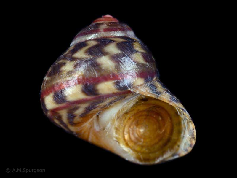
On seaweed, Horseshoe Bay, Stewart Island. 9mm
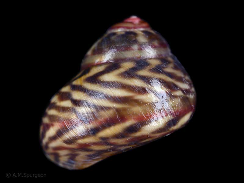
On seaweed, Horseshoe Bay, Stewart Island. 9mm
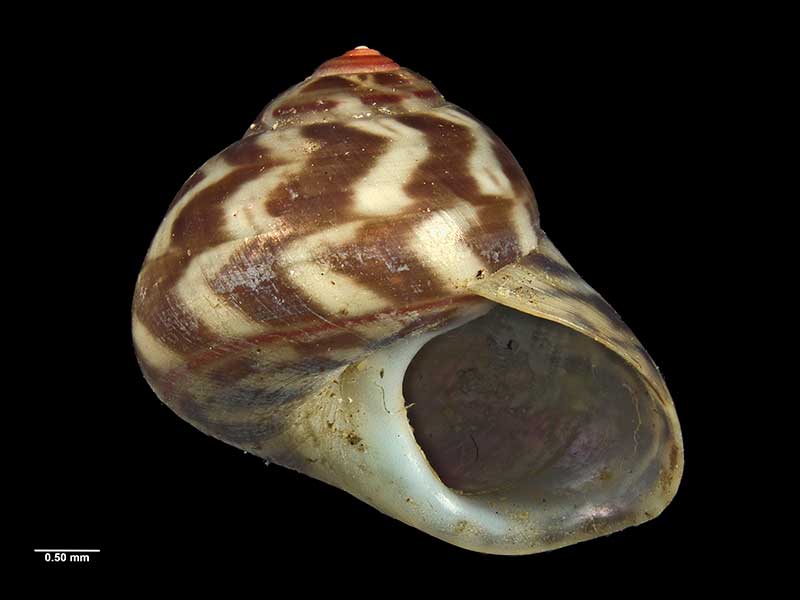
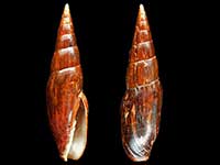
Holotype, collected Ulva Island, Paterson Inlet, Stewart Island, NZ (MA70442). © Auckland Museum (CC-BY)
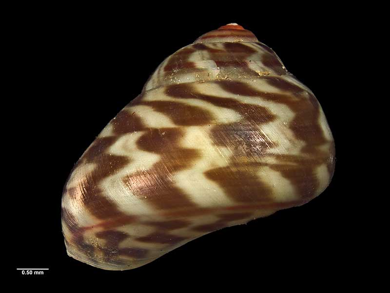
Holotype, collected Ulva Island, Paterson Inlet, Stewart Island, NZ (MA70442). © Auckland Museum (CC-BY)
Taxonomy
Family: Subfamily: TROCHIDAE: CANTHARIDINAE Full Classification: Mollusca (Phylum) > Gastropoda (Class) > Vetigastropoda (Subclass) > Trochida (Order) > Trochoidea (Superfamily) > Trochidae (Family) > Cantharidinae (Subfamily) > Cantharidus (Genus) > turneri (Species) Genus Synonyms: =Cantharidus (Cantharidus) Montfort, 1810 =Cantharidus (Plumbelenchus) Finlay, 1926 =Cantharidus (Pseudomargarella) Donald & Spencer, 2016 =Micrelenchus (Plumbelenchus) Finlay, 1926 =Trochus (Cantharidus) Montfort, 1810 Synonymised Names: =Cantharidus (Pseudomargarella) turneri (Powell, 1939) accepted, alternate representation =Margarella turneri Powell, 1939 |
Details: Cantharidus turneri (Powell, 1939)
Size/Grows to:
Width 9mm, Height 8mm
Distribution:
Southland, Stewart Island, Snares, Auckland and Campbell Islands. On seaweed covered rocks
Geographical Range:
FAn
Notes:
Species Links
Distribution Map
References and Publications
- Donald, K.M., Spencer, H.G. 2016 Phylogeographic patterns in New Zealand and temperate Australian cantharidines (Mollusca: Gastropoda: Trochidae: Cantharidinae): Trans-Tasman divergences are ancient, Molecular Phylogenetics and Evolution, 100 (p.341)
- Powell, A.W.B. 1979 New Zealand Mollusca: Marine, Land and Freshwater Shells, Collins, Auckland (p.51)
- Gardner, N.W. Mar/1976 About the Genus Margarella, Poirieria, 8(3) (p.55)
- Powell, A.W.B. 1939 The Mollusca of Stewart Island., Records of the Auckland Institute and Museum, 2 (p.227) Original Description
*98 © Museum of New Zealand Te Papa Tongarewa (CC-BY-NC-ND)
Key to Geographical Ranges

The symbols K.A.C.F.M.An. are used to indicate the geographical range of the species.
They have been adopted to give an approximation of the range of each species within New Zealand.
K=
Kermadec Islands
A=
Aupourian - Kaipara Harbour, north around North Cape, encompassing the Three Kings Islands and south to East Cape
C=
Cookian - Lower North Island and the northern part of the South Island
F=
Forsterian - Otago, Fiordland and Stewart Island
M=
Moriorian - Chatham Islands, Pitt Island
An=
Antipodean - Subantarctic Islands of New Zealand
Fw =
Freshwater
L =
Land
N =
North Island
S =
South Island
R =
Recent
Sf =
Subfossil
Fo =
Fossil

Compare Species (
/6)