Compare Phenacohelix mahlfeldae
| toggle to add to compare list |
Taxonomy
Family: Subfamily: CHAROPIDAE: PHENACOHELICINAE Full Classification: Mollusca (Phylum) > Gastropoda (Class) > Heterobranchia (Subclass) > Euthyneura (Infraclass) > Tectipleura (Subterclass) > Eupulmonata (Superorder) > Stylommatophora (Order) > Helicina (Suborder) > [unassigned] Helicina (Infraorder) > Punctoidea (Superfamily) > Charopidae (Family) > Phenacohelicinae (Subfamily) > Phenacohelix (Genus) > mahlfeldae (Species) Genus Synonyms: =Flammulina (Phenacohelix) Suter, 1892 |
Images: Phenacohelix mahlfeldae Goulstone, 2001

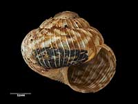
Holotype, collected Croydon Bush, NW of Gore, NZ (MA73174). 2.3mm. © Auckland Museum (CC-BY)

Holotype, collected Croydon Bush, NW of Gore, NZ (MA73174). 2.3mm. © Auckland Museum (CC-BY)

Holotype, collected Croydon Bush, NW of Gore, NZ (MA73174). 2.3mm. © Auckland Museum (CC-BY)

Collected 2011, Opoho Stream, Dunedin, Otago, NZ. 2.3mm. Reproduced courtesy of Dave Roscoe

Collected 2011, Opoho Stream, Dunedin, Otago, NZ. 2.3mm. Reproduced courtesy of Dave Roscoe

Collected 2011, Opoho Stream, Dunedin, Otago, NZ. 2.3mm. Reproduced courtesy of Dave Roscoe

Collected Feb 1976, West end Te Waewae Bay, Southland, NZ. 3.1mm. Reproduced courtesy of Dave Roscoe

Collected Feb 1976, West end Te Waewae Bay, Southland, NZ. 3.1mm. Reproduced courtesy of Dave Roscoe

Collected Feb 1976, West end Te Waewae Bay, Southland, NZ. 3.1mm. Reproduced courtesy of Dave Roscoe
Taxonomy
Family: Subfamily: CHAROPIDAE: PHENACOHELICINAE Full Classification: Mollusca (Phylum) > Gastropoda (Class) > Heterobranchia (Subclass) > Euthyneura (Infraclass) > Tectipleura (Subterclass) > Eupulmonata (Superorder) > Stylommatophora (Order) > Helicina (Suborder) > [unassigned] Helicina (Infraorder) > Punctoidea (Superfamily) > Charopidae (Family) > Phenacohelicinae (Subfamily) > Phenacohelix (Genus) > mahlfeldae (Species) Genus Synonyms: =Flammulina (Phenacohelix) Suter, 1892 |
Details: Phenacohelix mahlfeldae Goulstone, 2001
Distribution:
South Otago, Southland and Stewart Island
Geographical Range:
L.S.
Notes:
Species Links
Distribution Map
References and Publications
- Goulstone, J.F. 2001 A revision of the genus Phenacohelix Suter, 1892 (Mollusca: Pulmonata) with descriptions of four new species and reassignment of Thalassohelix ziczag (Gould, 1846), Records of the Auckland Institute and Museum, 38 (p.59) Original Description
Key to Geographical Ranges

The symbols K.A.C.F.M.An. are used to indicate the geographical range of the species.
They have been adopted to give an approximation of the range of each species within New Zealand.
K=
Kermadec Islands
A=
Aupourian - Kaipara Harbour, north around North Cape, encompassing the Three Kings Islands and south to East Cape
C=
Cookian - Lower North Island and the northern part of the South Island
F=
Forsterian - Otago, Fiordland and Stewart Island
M=
Moriorian - Chatham Islands, Pitt Island
An=
Antipodean - Subantarctic Islands of New Zealand
Fw =
Freshwater
L =
Land
N =
North Island
S =
South Island
R =
Recent
Sf =
Subfossil
Fo =
Fossil
Recently Viewed
Compare Species (
/6)