Compare Mesopeplum convexum
| toggle to add to compare list |
Taxonomy
Family: Subfamily: PECTINIDAE: PALLIOLINAE Full Classification: Mollusca (Phylum) > Bivalvia (Class) > Pteriomorphia (Subclass) > Pectinida (Order) > Pectinoidea (Superfamily) > Pectinidae (Family) > Palliolinae (Subfamily) > Mesopeplum (Genus) > convexum (Species) Genus Synonyms: =Dendopecten Hertlein, 1936 =Mesopeplum (Borehamia) Beu, 1978 accepted, alternate representation =Mesopeplum (Mesopeplum) Iredale, 1929 accepted, alternate representation Synonymised Names: =Pallium convexum (Quoy & Gaimard, 1835) =Pallium kapitiensis Mestayer, 1929 =Pecten (Dentipecten) vellicatus Hutton, 1873 =Pecten convexus Quoy & Gaimard, 1835 =Pecten roseopunctatus Reeve, 1853 |
Images: Mesopeplum convexum (Quoy & Gaimard, 1835)
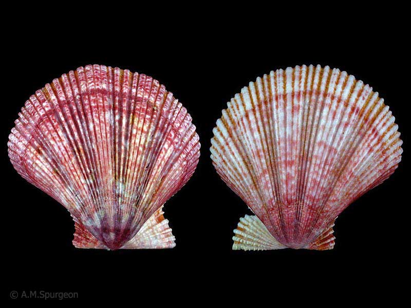
Living in Scallop Beds, Bay of Plenty, NZ. 41mm
Taxonomy
Family: Subfamily: PECTINIDAE: PALLIOLINAE Full Classification: Mollusca (Phylum) > Bivalvia (Class) > Pteriomorphia (Subclass) > Pectinida (Order) > Pectinoidea (Superfamily) > Pectinidae (Family) > Palliolinae (Subfamily) > Mesopeplum (Genus) > convexum (Species) Genus Synonyms: =Dendopecten Hertlein, 1936 =Mesopeplum (Borehamia) Beu, 1978 accepted, alternate representation =Mesopeplum (Mesopeplum) Iredale, 1929 accepted, alternate representation Synonymised Names: =Pallium convexum (Quoy & Gaimard, 1835) =Pallium kapitiensis Mestayer, 1929 =Pecten (Dentipecten) vellicatus Hutton, 1873 =Pecten convexus Quoy & Gaimard, 1835 =Pecten roseopunctatus Reeve, 1853 |
Details: Mesopeplum convexum (Quoy & Gaimard, 1835)
Size/Grows to:
Width 55mm, Height 50mm
Distribution:
Three Kings Islands, North, South, Stewart and Chatham Islands. Dredged to over 250 metes
Geographical Range:
ACFM
Notes:
Species Links
Distribution Map
References and Publications
- Dijkstra, H., Marshall, B.A. 2008 The Recent Pectinoidea of the New Zealand region (Mollusca: Bivalvia: Propeamussiidae, Pectinidae and Spondylidae), Molluscan Research, 28 (p.72)
- Powell, A.W.B. 1979 New Zealand Mollusca: Marine, Land and Freshwater Shells, Collins, Auckland (p.377)
Key to Geographical Ranges

The symbols K.A.C.F.M.An. are used to indicate the geographical range of the species.
They have been adopted to give an approximation of the range of each species within New Zealand.
K=
Kermadec Islands
A=
Aupourian - Kaipara Harbour, north around North Cape, encompassing the Three Kings Islands and south to East Cape
C=
Cookian - Lower North Island and the northern part of the South Island
F=
Forsterian - Otago, Fiordland and Stewart Island
M=
Moriorian - Chatham Islands, Pitt Island
An=
Antipodean - Subantarctic Islands of New Zealand
Fw =
Freshwater
L =
Land
N =
North Island
S =
South Island
R =
Recent
Sf =
Subfossil
Fo =
Fossil
Recently Viewed
Compare Species (
/6)