Compare Nemocardium enigmaticum
| toggle to add to compare list |
Taxonomy
Family: Subfamily: CARDIIDAE: LAEVICARDIINAE Full Classification: Mollusca (Phylum) > Bivalvia (Class) > Autobranchia (Subclass) > Heteroconchia (Infraclass) > Euhetrodonta (Subterclass) > Imparidentia (Superorder) > Cardiida (Order) > Cardioidea (Superfamily) > Cardiidae (Family) > Laevicardiinae (Subfamily) > Nemocardium (Genus) > enigmaticum (Species) Genus Synonyms: =Cardium (Nemocardium) Meek, 1876 =Nemocardium (Nemocardium) Meek, 1876 =Nemocardium (Varicardium) Marwick, 1944 =Varicardium Marwick, 1944 Synonymised Names: =Nemocardium probatum Powell not Iredale =Nemocardium bechei of authors not Reeve |
Images: Nemocardium enigmaticum ter Poorten, 2013
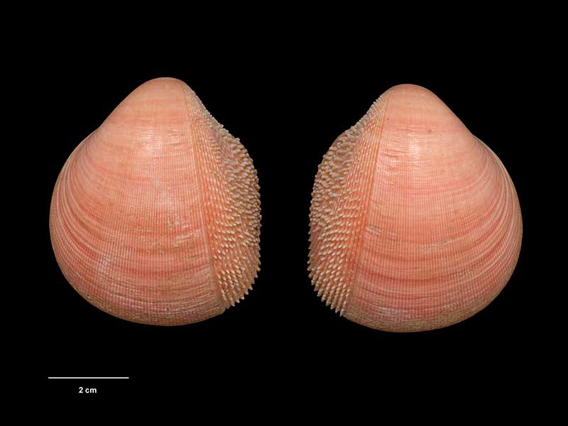
Holotype, collected 24 Aug 1972, off Hutchinson Bluff, Raoul Island, Kermadec Islands (M.222017). © Museum of New Zealand Te Papa Tongarewa (CC-BY-NC-ND)
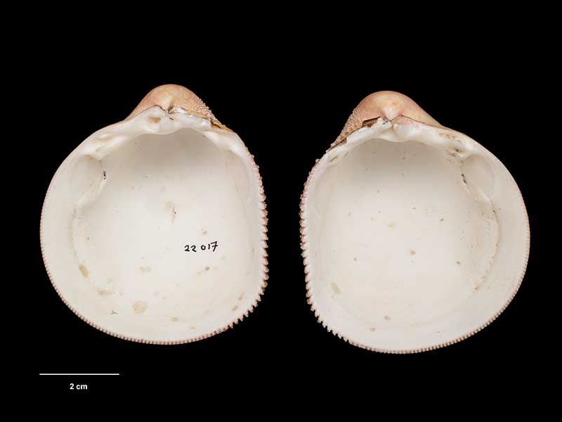
Holotype, collected 24 Aug 1972, off Hutchinson Bluff, Raoul Island, Kermadec Islands (M.222017). © Museum of New Zealand Te Papa Tongarewa (CC-BY-NC-ND)
Taxonomy
Family: Subfamily: CARDIIDAE: LAEVICARDIINAE Full Classification: Mollusca (Phylum) > Bivalvia (Class) > Autobranchia (Subclass) > Heteroconchia (Infraclass) > Euhetrodonta (Subterclass) > Imparidentia (Superorder) > Cardiida (Order) > Cardioidea (Superfamily) > Cardiidae (Family) > Laevicardiinae (Subfamily) > Nemocardium (Genus) > enigmaticum (Species) Genus Synonyms: =Cardium (Nemocardium) Meek, 1876 =Nemocardium (Nemocardium) Meek, 1876 =Nemocardium (Varicardium) Marwick, 1944 =Varicardium Marwick, 1944 Synonymised Names: =Nemocardium probatum Powell not Iredale =Nemocardium bechei of authors not Reeve |
Details: Nemocardium enigmaticum ter Poorten, 2013
Size/Grows to:
Height 68mm
Distribution:
Islands east of Australia: Lord Howe Island, Norfolk Ridge, Chesterfield-Bellona Plateau, New Caledonia, Loyalty Islands and the Kermadec Islands
Geographical Range:
K
Notes:
Species Links
Distribution Map
References and Publications
- ter Poorten, J.J. 2013 Revision of the Recent species of the genus Nemocardium Meek, 1876 (Bivalvia, Cardiidae), with the descriptions of three new species, Basteria, 77 (p.64) Original Description
- Powell, A.W.B. 1958 Mollusca of the Kermadec Islands. Part 1, Records of the Auckland Institute and Museum, 5(1) (p.75)
*98 © Museum of New Zealand Te Papa Tongarewa (CC-BY-NC-ND)
Key to Geographical Ranges

The symbols K.A.C.F.M.An. are used to indicate the geographical range of the species.
They have been adopted to give an approximation of the range of each species within New Zealand.
K=
Kermadec Islands
A=
Aupourian - Kaipara Harbour, north around North Cape, encompassing the Three Kings Islands and south to East Cape
C=
Cookian - Lower North Island and the northern part of the South Island
F=
Forsterian - Otago, Fiordland and Stewart Island
M=
Moriorian - Chatham Islands, Pitt Island
An=
Antipodean - Subantarctic Islands of New Zealand
Fw =
Freshwater
L =
Land
N =
North Island
S =
South Island
R =
Recent
Sf =
Subfossil
Fo =
Fossil
Recently Viewed
Compare Species (
/6)