Compare Barnea similis
| toggle to add to compare list |
Taxonomy
Family: Subfamily: PHOLADIDAE: PHOLADINAE Full Classification: Mollusca (Phylum) > Bivalvia (Class) > Autobranchia (Subclass) > Heteroconchia (Infraclass) > Euhetrodonta (Subterclass) > Imparidentia (Superorder) > Myida (Order) > Pholadoidea (Superfamily) > Pholadidae (Family) > Pholadinae (Subfamily) > Barnea (Genus) > similis (Species) Genus Synonyms: =Anchomasa Leach, 1852 =Barnea (Anchomasa) Leach, 1852 accepted, alternate representation =Barnea (Barnea) Risso, 1826 accepted, alternate representation Synonymised Names: =Barnea (Anchomasa) similis (Gray, 1835) accepted, alternate representation =Pholas antipodum Philippi, 1847 =Pholas similis Gray, 1835 |
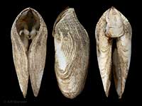
Images: Barnea similis (Gray, 1835)

Beachlands, Auckland, boring in soft mudstone. 58mm

Found inside soft mudstone at low tide, Cissy Bay, Marlborough Sounds, NZ. 50-60mm
Taxonomy
Family: Subfamily: PHOLADIDAE: PHOLADINAE Full Classification: Mollusca (Phylum) > Bivalvia (Class) > Autobranchia (Subclass) > Heteroconchia (Infraclass) > Euhetrodonta (Subterclass) > Imparidentia (Superorder) > Myida (Order) > Pholadoidea (Superfamily) > Pholadidae (Family) > Pholadinae (Subfamily) > Barnea (Genus) > similis (Species) Genus Synonyms: =Anchomasa Leach, 1852 =Barnea (Anchomasa) Leach, 1852 accepted, alternate representation =Barnea (Barnea) Risso, 1826 accepted, alternate representation Synonymised Names: =Barnea (Anchomasa) similis (Gray, 1835) accepted, alternate representation =Pholas antipodum Philippi, 1847 =Pholas similis Gray, 1835 |
Details: Barnea similis (Gray, 1835)
Size/Grows to:
Length 102mm, Height 35mm
Distribution:
North Island, far northern and eastern South Island, Stewart and Chatham Islands. Intertidal and immediate sublittoral, boring into soft rock
Geographical Range:
ACFM
Notes:
Species Links
Distribution Map
References and Publications
- Stevenson, A.G. Nov/2004 Collecting Rock Borers in New Zealand, Cookia, 16 (p.27)
- Powell, A.W.B. 1979 New Zealand Mollusca: Marine, Land and Freshwater Shells, Collins, Auckland (p.429)
Key to Geographical Ranges

The symbols K.A.C.F.M.An. are used to indicate the geographical range of the species.
They have been adopted to give an approximation of the range of each species within New Zealand.
K=
Kermadec Islands
A=
Aupourian - Kaipara Harbour, north around North Cape, encompassing the Three Kings Islands and south to East Cape
C=
Cookian - Lower North Island and the northern part of the South Island
F=
Forsterian - Otago, Fiordland and Stewart Island
M=
Moriorian - Chatham Islands, Pitt Island
An=
Antipodean - Subantarctic Islands of New Zealand
Fw =
Freshwater
L =
Land
N =
North Island
S =
South Island
R =
Recent
Sf =
Subfossil
Fo =
Fossil
Recently Viewed
Compare Species (
/6)