Compare Epitonium tenellum
| toggle to add to compare list |
Taxonomy
Family: EPITONIIDAE Full Classification: Mollusca (Phylum) > Gastropoda (Class) > Caenogastropoda (Subclass) > [unassigned] Caenogastropoda (Order) > Epitonioidea (Superfamily) > Epitoniidae (Family) > Epitonium (Genus) > tenellum (Species) Synonymised Names: =Epitonium (Papyriscala) tenellum (Hutton, 1885) accepted, alternate representation =Epitonium helicornuum (Iredale, 1936) =Epitonium novoseelandiae (Clessin, 1897) =Epitonium tenellum helicornuum (Iredale, 1936) =Limiscala helicornua Iredale, 1936 =Limiscala tenella (Hutton, 1885) =Scalaria novoseelandiae Clessin, 1897 =Scalaria tenella Hutton, 1885 |
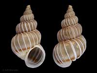
Images: Epitonium tenellum (Hutton, 1885)

In beach drift, Bland Bay, Northland, NZ. 14mm

In beach drift, Bland Bay, Northland, NZ. Close-up of varices. 14mm

Doubtless Bay, Northland, NZ. 18mm
Taxonomy
Family: EPITONIIDAE Full Classification: Mollusca (Phylum) > Gastropoda (Class) > Caenogastropoda (Subclass) > [unassigned] Caenogastropoda (Order) > Epitonioidea (Superfamily) > Epitoniidae (Family) > Epitonium (Genus) > tenellum (Species) Synonymised Names: =Epitonium (Papyriscala) tenellum (Hutton, 1885) accepted, alternate representation =Epitonium helicornuum (Iredale, 1936) =Epitonium novoseelandiae (Clessin, 1897) =Epitonium tenellum helicornuum (Iredale, 1936) =Limiscala helicornua Iredale, 1936 =Limiscala tenella (Hutton, 1885) =Scalaria novoseelandiae Clessin, 1897 =Scalaria tenella Hutton, 1885 |
Details: Epitonium tenellum (Hutton, 1885)
Size/Grows to:
Height 20mm, Width 9mm
Distribution:
Northland to Nelson/Marlborough, in silty sand. Also Queensland to Victoria, Australia
Geographical Range:
AC
Notes:
Species Links
Distribution Map
References and Publications
- Powell, A.W.B. 1979 New Zealand Mollusca: Marine, Land and Freshwater Shells, Collins, Auckland (p.251)
- Hutton, F.W. 1885 Revision of the marine taeniglossate and ptenoglossate Mollusca of New Zealand, Proceedings of the Linnean Society of New South Wales, 9 (p.943) Original Description
Key to Geographical Ranges

The symbols K.A.C.F.M.An. are used to indicate the geographical range of the species.
They have been adopted to give an approximation of the range of each species within New Zealand.
K=
Kermadec Islands
A=
Aupourian - Kaipara Harbour, north around North Cape, encompassing the Three Kings Islands and south to East Cape
C=
Cookian - Lower North Island and the northern part of the South Island
F=
Forsterian - Otago, Fiordland and Stewart Island
M=
Moriorian - Chatham Islands, Pitt Island
An=
Antipodean - Subantarctic Islands of New Zealand
Fw =
Freshwater
L =
Land
N =
North Island
S =
South Island
R =
Recent
Sf =
Subfossil
Fo =
Fossil
Recently Viewed
Compare Species (
/6)