Compare Cirsotrema zelebori
| toggle to add to compare list |
Taxonomy
Family: EPITONIIDAE Full Classification: Mollusca (Phylum) > Gastropoda (Class) > Caenogastropoda (Subclass) > [unassigned] Caenogastropoda (Order) > Epitonioidea (Superfamily) > Epitoniidae (Family) > Cirsotrema (Genus) > zelebori (Species) Genus Synonyms: =Cirsotrema (Tioria) Marwick, 1928 =Scala (Cirsotrema) Mörch, 1852 =Scalaria (Cirsotrema) Mörch, 1852 =Tioria Marwick, 1928 Synonymised Names: =Boreoscala zelebori (Dunker, 1866) =Cirsotrema reevei (Clessin, 1897) =Epitonium zelebori (Dunker, 1866) =Scalaria intermedia Hutton, 1873 =Scalaria reevei Clessin, 1897 =Scalaria zelebori Dunker, 1866 =Tioria forresti (Dell, 1956) |
Images: Cirsotrema zelebori (Dunker, 1866)
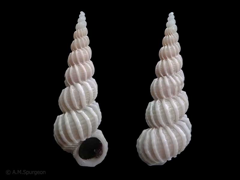
Washed up alive on beach with animal, Rarawa, Far North, NZ. 24mm

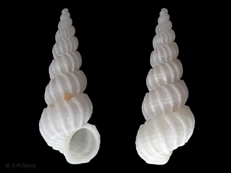
Close-up showing sculpture. Rarawa, Far North, NZ. 24mm
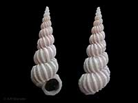
Found washed up on ocean beaches. 16mm
Taxonomy
Family: EPITONIIDAE Full Classification: Mollusca (Phylum) > Gastropoda (Class) > Caenogastropoda (Subclass) > [unassigned] Caenogastropoda (Order) > Epitonioidea (Superfamily) > Epitoniidae (Family) > Cirsotrema (Genus) > zelebori (Species) Genus Synonyms: =Cirsotrema (Tioria) Marwick, 1928 =Scala (Cirsotrema) Mörch, 1852 =Scalaria (Cirsotrema) Mörch, 1852 =Tioria Marwick, 1928 Synonymised Names: =Boreoscala zelebori (Dunker, 1866) =Cirsotrema reevei (Clessin, 1897) =Epitonium zelebori (Dunker, 1866) =Scalaria intermedia Hutton, 1873 =Scalaria reevei Clessin, 1897 =Scalaria zelebori Dunker, 1866 =Tioria forresti (Dell, 1956) |
Details: Cirsotrema zelebori (Dunker, 1866)
Size/Grows to:
Height 33mm, Width 12mm
Distribution:
Three Kings Islands, North, South, Stewart and Chatham Islands
Geographical Range:
ACFM
Notes:
Species Links
Distribution Map
References and Publications
- Smith, N. Oct/1996 Notes on two Epitoniums, Poirieria, 19 (p.38)
- Powell, A.W.B. 1979 New Zealand Mollusca: Marine, Land and Freshwater Shells, Collins, Auckland (p.252)
Key to Geographical Ranges

The symbols K.A.C.F.M.An. are used to indicate the geographical range of the species.
They have been adopted to give an approximation of the range of each species within New Zealand.
K=
Kermadec Islands
A=
Aupourian - Kaipara Harbour, north around North Cape, encompassing the Three Kings Islands and south to East Cape
C=
Cookian - Lower North Island and the northern part of the South Island
F=
Forsterian - Otago, Fiordland and Stewart Island
M=
Moriorian - Chatham Islands, Pitt Island
An=
Antipodean - Subantarctic Islands of New Zealand
Fw =
Freshwater
L =
Land
N =
North Island
S =
South Island
R =
Recent
Sf =
Subfossil
Fo =
Fossil
Recently Viewed
Compare Species (
/6)