Compare Roseaplagis artizona
| toggle to add to compare list |
Taxonomy
Family: Subfamily: TROCHIDAE: CANTHARIDINAE Full Classification: Mollusca (Phylum) > Gastropoda (Class) > Vetigastropoda (Subclass) > Trochida (Order) > Trochoidea (Superfamily) > Trochidae (Family) > Cantharidinae (Subfamily) > Roseaplagis (Genus) > artizona (Species) Synonymised Names: =Cantharidus artizona A. Adams, 1853 =Cantharidus sanguineus bakeri (C.A. Fleming, 1948) =Cantharidus sanguineus var. elongata Suter, 1897 =Gibbula (Cantharidella) micans Suter, 1897 =Gibbula micans Suter, 1897 =Micrelenchus (Plumbelenchus) artizona (A. Adams, 1853) =Micrelenchus artizona (A. Adams, 1853) =Micrelenchus sanguineus bakeri C.A. Fleming, 1948 |
Images: Roseaplagis artizona A. Adams, 1853

Stewart Island, NZ. 5.5mm
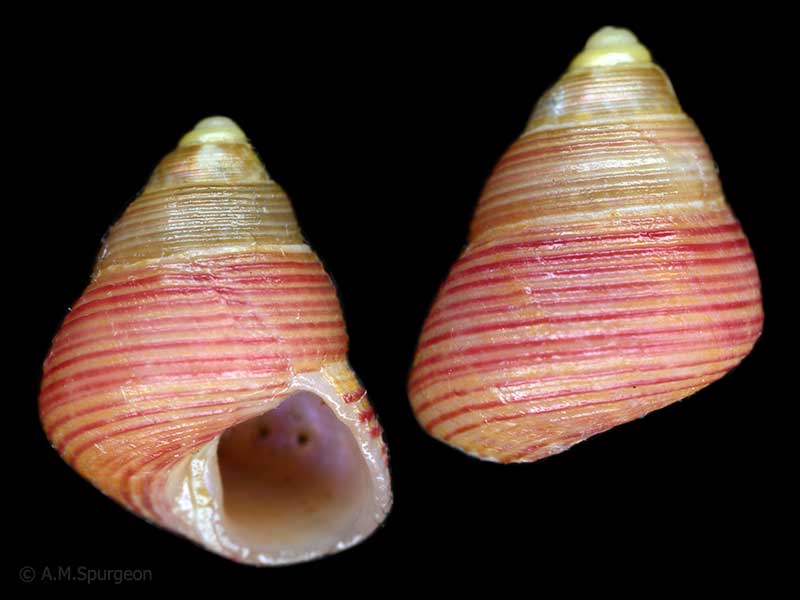
In beach drift, Tahunanui Beach, Nelson, NZ. 5.25mm
Taxonomy
Family: Subfamily: TROCHIDAE: CANTHARIDINAE Full Classification: Mollusca (Phylum) > Gastropoda (Class) > Vetigastropoda (Subclass) > Trochida (Order) > Trochoidea (Superfamily) > Trochidae (Family) > Cantharidinae (Subfamily) > Roseaplagis (Genus) > artizona (Species) Synonymised Names: =Cantharidus artizona A. Adams, 1853 =Cantharidus sanguineus bakeri (C.A. Fleming, 1948) =Cantharidus sanguineus var. elongata Suter, 1897 =Gibbula (Cantharidella) micans Suter, 1897 =Gibbula micans Suter, 1897 =Micrelenchus (Plumbelenchus) artizona (A. Adams, 1853) =Micrelenchus artizona (A. Adams, 1853) =Micrelenchus sanguineus bakeri C.A. Fleming, 1948 |
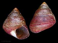
Details: Roseaplagis artizona A. Adams, 1853
Size/Grows to:
Height 8mm, Width 6mm
Distribution:
Southern North Island to Stewart Island
Notes:
Species Links
Distribution Map
References and Publications
- Donald, K.M., Spencer, H.G. 2016 Phylogeographic patterns in New Zealand and temperate Australian cantharidines (Mollusca: Gastropoda: Trochidae: Cantharidinae): Trans-Tasman divergences are ancient, Molecular Phylogenetics and Evolution, 100 (p.341)
- Marshall, B.A. 1998 The New Zealand Recent species of Cantharidus Montfort, 1810 and Micrelenchus Finlay, 1926 (Mollusca: Gastropoda: Trochidae), Molluscan Research, 19 (p.137)
- Powell, A.W.B. 1979 New Zealand Mollusca: Marine, Land and Freshwater Shells, Collins, Auckland (p.56)
- Adams, A. 1853 Contributions towards a monograph of the Trochidae, a family of gasteropodous Mollusca, Proceedings of the Zoological Society of London, 19 (p.170) Original Description
*98 © Museum of New Zealand Te Papa Tongarewa (CC-BY-NC-ND)
NZ Geographical Regions

Key to symbols used in Checklist.
Fw =
Freshwater
L =
Land
N =
North Island
S =
South Island
R =
Recent
Sf =
Subfossil
Fo =
Fossil
Recently Viewed
Compare Species (
/6)