Compare Oocorys sulcata
| toggle to add to compare list |
Taxonomy
Family: Subfamily: CASSIDAE: CASSINAE Full Classification: Synonymised Names: =Benthodolium abyssorum Verrill & S. Smith, 1884 =Dolium (Eudolium) aulacodes (Tomlin, 1927) =Eudolium aulacodes Tomlin, 1927 =Oocorys abyssorum (Verrill & S. Smith, 1884) =Oocorys elongata Schepman, 1909 =Oocorys fischeri Locard, 1897 =Oocorys fischeri var. minor Locard, 1897 =Oocorys rotunda Dall, 1908 =Oocorys schepmani R.D. Turner, 1948 =Oocorys sulcata var. elongata Locard, 1897 =Oocorys sulcata var. indica E.A. Smith, 1906 =Oocorys sulcata var. minor Locard, 1897 =Oocorys umbilicata Quinn, 1980 =Oocorys watsoni Locard, 1897 =Oocorys weberi Schepman, 1909 =Tonna (Eudolium) aulacodes (Tomlin, 1927) |
Images: Oocorys sulcata Fischer, 1884
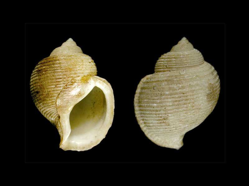
Lectotype - North Atlantic Ocean. 36.6mm. Muséum National d’Histoire Naturelle, Paris
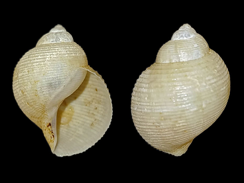
Off Hawkes Bay, NZ. © rights reserved
Taxonomy
Family: Subfamily: CASSIDAE: CASSINAE Full Classification: Synonymised Names: =Benthodolium abyssorum Verrill & S. Smith, 1884 =Dolium (Eudolium) aulacodes (Tomlin, 1927) =Eudolium aulacodes Tomlin, 1927 =Oocorys abyssorum (Verrill & S. Smith, 1884) =Oocorys elongata Schepman, 1909 =Oocorys fischeri Locard, 1897 =Oocorys fischeri var. minor Locard, 1897 =Oocorys rotunda Dall, 1908 =Oocorys schepmani R.D. Turner, 1948 =Oocorys sulcata var. elongata Locard, 1897 =Oocorys sulcata var. indica E.A. Smith, 1906 =Oocorys sulcata var. minor Locard, 1897 =Oocorys umbilicata Quinn, 1980 =Oocorys watsoni Locard, 1897 =Oocorys weberi Schepman, 1909 =Tonna (Eudolium) aulacodes (Tomlin, 1927) |
Details: Oocorys sulcata Fischer, 1884
Size/Grows to:
Height 55mm, Width 35mm
Distribution:
Cosmopolitan. Lord Howe Rise, W of Three Kings Islands and off Cape Runaway
Notes:
Species Links
Distribution Map
References and Publications
- Beu, A.G., Bouchet, P., Tröndlé, J. 2012 Tonnoidean gastropods of French Polynesia, Molluscan Research, 32(2) (p.82)
- Rex, M.A., Stuart, C.T., Etter, R.J., McClain, C.R. 2010 Biogeography of the Deep-Sea Gastropod Oocorys sulcata Fischer 1884, Journal of Conchology, 40(3) (p.287)
- Beu, A.G. 2008 Recent deep-water Cassidae of the world. A revision of Galeodea, Oocorys, Sconsia, Echinophoria and related taxa, with new genera and species (Mollusca, Gastropoda). In Héros, V., Cowie, R.H. & Bouchet, P. (eds), Tropical Deep-Sea Benthos 25, Mémoires du Muséum National d'Histoire Naturelle, 196 (p.342)
*98 © Museum of New Zealand Te Papa Tongarewa (CC-BY-NC-ND)
NZ Geographical Regions

Key to symbols used in Checklist.
Fw =
Freshwater
L =
Land
N =
North Island
S =
South Island
R =
Recent
Sf =
Subfossil
Fo =
Fossil
Recently Viewed
Compare Species (
/6)