Compare Hadopyrgus rawhiti
| toggle to add to compare list |
Taxonomy
Family: TATEIDAE Full Classification: Mollusca (Phylum) > Gastropoda (Class) > Caenogastropoda (Subclass) > Littorinimorpha (Order) > Truncatelloidea (Superfamily) > Tateidae (Family) > Hadopyrgus (Genus) > rawhiti (Species) |
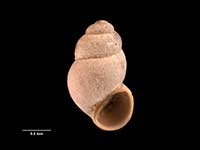
Images: Hadopyrgus rawhiti Haase, 2008

Holotype, collected 13 Dec 1982, seepage by waterfall in stream between Hopewell & Raetihi, behind Double Bay, Kenepuru Sound, NNE of Picton, NZ (M.174193). 1.9mm. © Museum of New Zealand Te Papa Tongarewa (CC-BY-NC-ND)

Behind Raetihi Lodge, Kenepuru Sound, NNE of Picton, NZ. 1.8mm
Taxonomy
Family: TATEIDAE Full Classification: Mollusca (Phylum) > Gastropoda (Class) > Caenogastropoda (Subclass) > Littorinimorpha (Order) > Truncatelloidea (Superfamily) > Tateidae (Family) > Hadopyrgus (Genus) > rawhiti (Species) |
Details: Hadopyrgus rawhiti Haase, 2008
Size/Grows to:
Height 2.0mm, Width 1.2mm
Distribution:
South Island. Between Hopewell and Raetihi, Marlborough Sounds. Only known from the type locality
Notes:
Species Links
Distribution Map
References and Publications
- Haase, M. 2008 The radiation of hydrobiid gastropods in New Zealand: a revision including the description of new species based on morphology and mtDNA sequence information, Systematics and Biodiversity, 6(1) (p.133) Original Description
NZ Geographical Regions

Key to symbols used in Checklist.
Fw =
Freshwater
L =
Land
N =
North Island
S =
South Island
R =
Recent
Sf =
Subfossil
Fo =
Fossil
Recently Viewed
Compare Species (
/6)