Compare Diacria trispinosa
| toggle to add to compare list |
Taxonomy
Family: CAVOLINIIDAE Full Classification: Mollusca (Phylum) > Gastropoda (Class) > Heterobranchia (Subclass) > Euthyneura (Infraclass) > Tectipleura (Subterclass) > Pteropoda (Order) > Euthecosomata (Suborder) > Cavolinioidea (Superfamily) > Cavoliniidae (Family) > Diacria (Genus) > trispinosa (Species) Genus Synonyms: =Hyalaea (Diacria) Gray, 1840 Synonymised Names: =Cavolinia reeveana Dunker, 1853 =Cavolinia trispinosa (Blainville, 1821) =Cleodora compressa Souleyet, 1852 =Diacria atlantica Dupont, 1998 =Diacria rubecula Bontes & van der Spoel, 1998 =Diacria trispinosa heterocolorata Rampal, 2002 =Hyalaea depressa Bivona-Bernardi, 1832 =Hyalaea mucronata Quoy & Gaimard, 1827 =Hyalaea reeveana Dunker, 1853 =Hyalaea trispinosa Blainville, 1821 |
Images: Diacria trispinosa (Blainville, 1821)

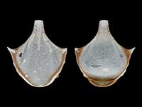
Holotype of Diacria trispinosa heterocolarata, collected 12 Apr 1977, 335-390 metres, SE of Glorioso Islands, Mozambique Channel, Indian Ocean. 6.4mm. Muséum National d’Histoire Naturelle, Paris
Taxonomy
Family: CAVOLINIIDAE Full Classification: Mollusca (Phylum) > Gastropoda (Class) > Heterobranchia (Subclass) > Euthyneura (Infraclass) > Tectipleura (Subterclass) > Pteropoda (Order) > Euthecosomata (Suborder) > Cavolinioidea (Superfamily) > Cavoliniidae (Family) > Diacria (Genus) > trispinosa (Species) Genus Synonyms: =Hyalaea (Diacria) Gray, 1840 Synonymised Names: =Cavolinia reeveana Dunker, 1853 =Cavolinia trispinosa (Blainville, 1821) =Cleodora compressa Souleyet, 1852 =Diacria atlantica Dupont, 1998 =Diacria rubecula Bontes & van der Spoel, 1998 =Diacria trispinosa heterocolorata Rampal, 2002 =Hyalaea depressa Bivona-Bernardi, 1832 =Hyalaea mucronata Quoy & Gaimard, 1827 =Hyalaea reeveana Dunker, 1853 =Hyalaea trispinosa Blainville, 1821 |
Details: Diacria trispinosa (Blainville, 1821)
Size/Grows to:
Height 7mm, Width 6.3mm
Distribution:
Off Three Kings Islands to Bay of Plenty. All seas, especially the Atlantic
Notes:
Species Links
Distribution Map
References and Publications
- Powell, A.W.B. 1979 New Zealand Mollusca: Marine, Land and Freshwater Shells, Collins, Auckland (p.278)
- Bé, A.W.H., Gilmer, R.W. 1977 A zoogeographic and taxonomic review of Euthecosomatous Pteropoda. In A.T.S. Ramsay (ed.), Oceanic Micropaleontology, Academic Press, London, 1 (p.785)
*98 © Museum of New Zealand Te Papa Tongarewa (CC-BY-NC-ND)
NZ Geographical Regions

Key to symbols used in Checklist.
Fw =
Freshwater
L =
Land
N =
North Island
S =
South Island
R =
Recent
Sf =
Subfossil
Fo =
Fossil
Recently Viewed
Compare Species (
/6)