Compare Scaphander otagoensis
| toggle to add to compare list |
Taxonomy
Family: SCAPHANDRIDAE Full Classification: Mollusca (Phylum) > Gastropoda (Class) > Heterobranchia (Subclass) > Euthyneura (Infraclass) > Tectipleura (Subterclass) > Cephalaspidea (Order) > Philinoidea (Superfamily) > Scaphandridae (Family) > Scaphander (Genus) > otagoensis (Species) Genus Synonyms: =Assula Schumacher, 1817 =Brocktonia Iredale, 1915 =Bucconia Dall, 1890 =Bullocardia F. Nordsieck, 1972 =Gioenia Bruguière, 1789 =Meloscaphander Schepman, 1913 =Nipponoscaphander Kuroda & Habe, 1971 =Scaphander (Sabatina) Dall, 1908 =Tricla Philippson, 1788 |
Images: Scaphander otagoensis Dell, 1956
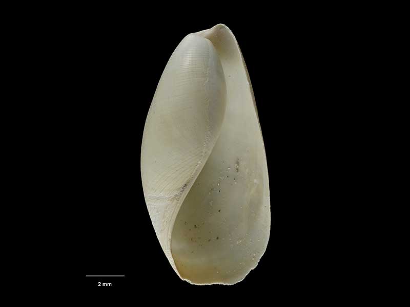
Holotype, collected 28 Mar 1954, off Otago Peninsula, Karitane Canyon, NZ (M.009141). 13mm. © Museum of New Zealand Te Papa Tongarewa (CC-BY-NC-ND)
Holotype, collected 28 Mar 1954, off Otago Peninsula, Karitane Canyon, NZ (M.009141). 13mm. © Museum of New Zealand Te Papa Tongarewa (CC-BY-NC-ND)
Taxonomy
Family: SCAPHANDRIDAE Full Classification: Mollusca (Phylum) > Gastropoda (Class) > Heterobranchia (Subclass) > Euthyneura (Infraclass) > Tectipleura (Subterclass) > Cephalaspidea (Order) > Philinoidea (Superfamily) > Scaphandridae (Family) > Scaphander (Genus) > otagoensis (Species) Genus Synonyms: =Assula Schumacher, 1817 =Brocktonia Iredale, 1915 =Bucconia Dall, 1890 =Bullocardia F. Nordsieck, 1972 =Gioenia Bruguière, 1789 =Meloscaphander Schepman, 1913 =Nipponoscaphander Kuroda & Habe, 1971 =Scaphander (Sabatina) Dall, 1908 =Tricla Philippson, 1788 |
Details: Scaphander otagoensis Dell, 1956
Size/Grows to:
Height 39mm, Width 17mm
Distribution:
Off North, South, and Chatham Islands, from around 360-650 metres
Geographical Range:
F
Notes:
Species Links
Distribution Map
References and Publications
- Powell, A.W.B. 1979 New Zealand Mollusca: Marine, Land and Freshwater Shells, Collins, Auckland (p.271)
- Dell, R.K. 1956 The archibenthal Mollusca of New Zealand, Dominion Museum Bulletin, 18 (p.143) Original Description
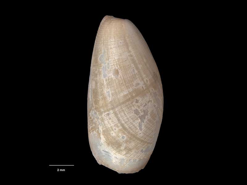
*98 © Museum of New Zealand Te Papa Tongarewa (CC-BY-NC-ND)
Key to Geographical Ranges

The symbols K.A.C.F.M.An. are used to indicate the geographical range of the species.
They have been adopted to give an approximation of the range of each species within New Zealand.
K=
Kermadec Islands
A=
Aupourian - Kaipara Harbour, north around North Cape, encompassing the Three Kings Islands and south to East Cape
C=
Cookian - Lower North Island and the northern part of the South Island
F=
Forsterian - Otago, Fiordland and Stewart Island
M=
Moriorian - Chatham Islands, Pitt Island
An=
Antipodean - Subantarctic Islands of New Zealand
Fw =
Freshwater
L =
Land
N =
North Island
S =
South Island
R =
Recent
Sf =
Subfossil
Fo =
Fossil
Recently Viewed
Compare Species (
/6)