Compare Rissoella micra
| toggle to add to compare list |
Taxonomy
Family: RISSOELLIDAE Full Classification: Mollusca (Phylum) > Gastropoda (Class) > Heterobranchia (Subclass) > Euthyneura (Infraclass) > Acteonimorpha (Subterclass) > Rissoelloidea (Superfamily) > Rissoellidae (Family) > Rissoella (Genus) > micra (Species) Genus Synonyms: =Heterorissoa Iredale, 1912 =Jeffreysia Alder, 1850 =Jeffreysiella Thiele, 1912 =Jeffreysina Thiele, 1925 =Jeffreysiopsis Thiele, 1912 =Rissoella (Jeffreysiella) Thiele, 1912 =Rissoella (Phycodrosus) Rehder, 1943 =Rissoella (Rissoella) Gray, 1847 =Rissoella (Zelaxitas) Finlay, 1926 =Zelaxitas Finlay, 1926 Synonymised Names: =Laevilitorina micra Finlay, 1924 =Notosetia fulva Laseron, 1950 =Rissoella (Zelaxitas) micra (Finlay, 1924) accepted, alternate representation |
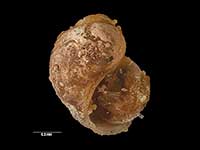
Images: Rissoella micra (Finlay, 1924)

Holotype, collected pre 1924, Taieri Beach, Otago, NZ (MA70383). © Auckland Museum (CC-BY)
Taxonomy
Family: RISSOELLIDAE Full Classification: Mollusca (Phylum) > Gastropoda (Class) > Heterobranchia (Subclass) > Euthyneura (Infraclass) > Acteonimorpha (Subterclass) > Rissoelloidea (Superfamily) > Rissoellidae (Family) > Rissoella (Genus) > micra (Species) Genus Synonyms: =Heterorissoa Iredale, 1912 =Jeffreysia Alder, 1850 =Jeffreysiella Thiele, 1912 =Jeffreysina Thiele, 1925 =Jeffreysiopsis Thiele, 1912 =Rissoella (Jeffreysiella) Thiele, 1912 =Rissoella (Phycodrosus) Rehder, 1943 =Rissoella (Rissoella) Gray, 1847 =Rissoella (Zelaxitas) Finlay, 1926 =Zelaxitas Finlay, 1926 Synonymised Names: =Laevilitorina micra Finlay, 1924 =Notosetia fulva Laseron, 1950 =Rissoella (Zelaxitas) micra (Finlay, 1924) accepted, alternate representation |
Details: Rissoella micra (Finlay, 1924)
Size/Grows to:
Height 0.6mm, Width 0.7mm
Distribution:
North and South Island. Fiordland, Stewart, Campbell and Chatham Islands
Geographical Range:
ACFMAn
Notes:
Species Links
Distribution Map
References and Publications
- Powell, A.W.B. 1979 New Zealand Mollusca: Marine, Land and Freshwater Shells, Collins, Auckland (p.120)
- Ponder, W.F., Yoo, E.K. 1977 A revision of the Australian species of the Rissoellidae (Mollusca: Gastropoda), Records of the Australian Museum, 31 (p.152)
- Finlay, H. 1924 Additions to the Recent Molluscan Fauna of New Zealand, Transactions and Proceedings of the Royal Society of New Zealand, 55 (p.522) Original Description
*98 © Museum of New Zealand Te Papa Tongarewa (CC-BY-NC-ND)
Key to Geographical Ranges

The symbols K.A.C.F.M.An. are used to indicate the geographical range of the species.
They have been adopted to give an approximation of the range of each species within New Zealand.
K=
Kermadec Islands
A=
Aupourian - Kaipara Harbour, north around North Cape, encompassing the Three Kings Islands and south to East Cape
C=
Cookian - Lower North Island and the northern part of the South Island
F=
Forsterian - Otago, Fiordland and Stewart Island
M=
Moriorian - Chatham Islands, Pitt Island
An=
Antipodean - Subantarctic Islands of New Zealand
Fw =
Freshwater
L =
Land
N =
North Island
S =
South Island
R =
Recent
Sf =
Subfossil
Fo =
Fossil
Recently Viewed
Compare Species (
/6)