Compare Neoguraleus sinclairi
| toggle to add to compare list |
Taxonomy
Family: MANGELIIDAE Full Classification: Mollusca (Phylum) > Gastropoda (Class) > Caenogastropoda (Subclass) > Neogastropoda (Order) > Conoidea (Superfamily) > Mangeliidae (Family) > Neoguraleus (Genus) > sinclairi (Species) Synonymised Names: =Defrancia luteofasciata Hutton, 1881 =Drillia sinclairi Gillies, 1882 =Neoguraleus sinclairi (E.A. Smith, 1884) =Neoguraleus whangaroaensis Powell, 1942 =Pleurotoma (Mangilia) sinclairii E.A. Smith, 1884 =Pleurotoma sinclairii E.A. Smith, 1884 |
Images: Neoguraleus sinclairi (Gillies, 1882)

Lectotype of Drillia sinclairi Gillies, 1882, collected no other data, NZ (M.000061). 10mm. © Museum of New Zealand Te Papa Tongarewa (CC-BY-NC-ND)

Holotype of Neoguraleus whangaroaensis Powell, 1942, collected Taupo Bay, Whangaroa, NZ (MA71053). © Auckland Museum (CC-BY)

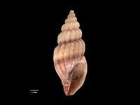
Collected Nov 201423, Karehana Bay Plimmerton, NZ. 8mm
Taxonomy
Family: MANGELIIDAE Full Classification: Mollusca (Phylum) > Gastropoda (Class) > Caenogastropoda (Subclass) > Neogastropoda (Order) > Conoidea (Superfamily) > Mangeliidae (Family) > Neoguraleus (Genus) > sinclairi (Species) Synonymised Names: =Defrancia luteofasciata Hutton, 1881 =Drillia sinclairi Gillies, 1882 =Neoguraleus sinclairi (E.A. Smith, 1884) =Neoguraleus whangaroaensis Powell, 1942 =Pleurotoma (Mangilia) sinclairii E.A. Smith, 1884 =Pleurotoma sinclairii E.A. Smith, 1884 |
Details: Neoguraleus sinclairi (Gillies, 1882)
Size/Grows to:
Height 12mm, Width 4.5mm
Distribution:
North, South and Stewart Islands
Notes:
Species Links
Distribution Map
References and Publications
- Powell, A.W.B. 1979 New Zealand Mollusca: Marine, Land and Freshwater Shells, Collins, Auckland (p.238)
- Powell, A.W.B. 1942 The New Zealand Recent and fossil Mollusca of the family Turridae with general notes on turrid nomenclature and systematics, Auckland Institute and Museum Bulletin, 2 (p.135)
- Gillies, J. 1882 Notes on New Zealand Mollusca, Transactions and Proceedings of the New Zealand Institute, 14(147) (p.171) Original Description
NZ Geographical Regions

Key to symbols used in Checklist.
Fw =
Freshwater
L =
Land
N =
North Island
S =
South Island
R =
Recent
Sf =
Subfossil
Fo =
Fossil
Recently Viewed
Compare Species (
/6)