Compare Neoguraleus lyallensis
| toggle to add to compare list |
Taxonomy
Family: MANGELIIDAE Full Classification: Mollusca (Phylum) > Gastropoda (Class) > Caenogastropoda (Subclass) > Neogastropoda (Order) > Conoidea (Superfamily) > Mangeliidae (Family) > Neoguraleus (Genus) > lyallensis (Species) Synonymised Names: =Drillia lyallensis R. Murdoch, 1905 =Guraleus tenebrosus Powell, 1926 =Neoguraleus lyallensis lyallensis (R. Murdoch, 1905) =Neoguraleus lyallensis tenebrosus (Powell, 1926) =Neoguraleus tenebrosus Powell, 1926 |
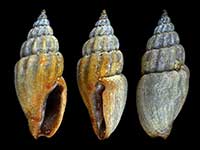
Images: Neoguraleus lyallensis (R. Murdoch, 1905)

Oneroa, Waiheke Island. 13mm

Waitangi, Bay of Islands, Northland, NZ. 13mm

Below low tide on sandy gravel, Henderson Bay, Far North, NZ. 10.5mm

Holotype of Guraleus tenebrosus Powell, 1926, collected Taupo Bay, Far North, NZ (MA72067). © Auckland Museum (CC-BY)
Taxonomy
Family: MANGELIIDAE Full Classification: Mollusca (Phylum) > Gastropoda (Class) > Caenogastropoda (Subclass) > Neogastropoda (Order) > Conoidea (Superfamily) > Mangeliidae (Family) > Neoguraleus (Genus) > lyallensis (Species) Synonymised Names: =Drillia lyallensis R. Murdoch, 1905 =Guraleus tenebrosus Powell, 1926 =Neoguraleus lyallensis lyallensis (R. Murdoch, 1905) =Neoguraleus lyallensis tenebrosus (Powell, 1926) =Neoguraleus tenebrosus Powell, 1926 |
Details: Neoguraleus lyallensis (R. Murdoch, 1905)
Size/Grows to:
Height 13mm, Width 5.5mm
Distribution:
North, South and Stewart Island
Notes:
Species Links
Distribution Map
References and Publications
- Powell, A.W.B. 1979 New Zealand Mollusca: Marine, Land and Freshwater Shells, Collins, Auckland (p.238)
- Powell, A.W.B. 1942 The New Zealand Recent and fossil Mollusca of the family Turridae with general notes on turrid nomenclature and systematics, Auckland Institute and Museum Bulletin, 2 (p.138)
- Murdoch, R. 1905 Additions to the marine Mollusca of New Zealand., Transactions and Proceedings of the New Zealand Institute, 37 (p.221) Original Description
NZ Geographical Regions

Key to symbols used in Checklist.
Fw =
Freshwater
L =
Land
N =
North Island
S =
South Island
R =
Recent
Sf =
Subfossil
Fo =
Fossil
Recently Viewed
Compare Species (
/6)