Compare Conasprella howelli
| toggle to add to compare list |
Taxonomy
Family: CONIDAE Full Classification: Mollusca (Phylum) > Gastropoda (Class) > Caenogastropoda (Subclass) > Neogastropoda (Order) > Conoidea (Superfamily) > Conidae (Family) > Conasprella (Genus) > howelli (Species) Synonymised Names: =Conasprella (Endemoconus) howelli (Iredale, 1929) accepted, alternate representation =Conus howelli Iredale, 1929 =Endemoconus howelli (Iredale, 1929) |
Images: Conasprella howelli (Iredale, 1929)

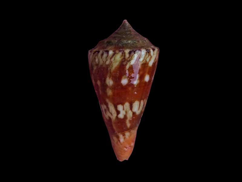
From approx. 95 metres off Ranfurly Bank, East Cape, NZ. 20mm
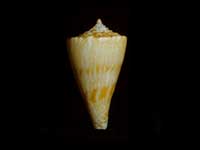
Dredged in 30 metres, off Coromandel, Bay of Plenty, NZ. 38mm. Courtesy of Claire Elliot
Taxonomy
Family: CONIDAE Full Classification: Mollusca (Phylum) > Gastropoda (Class) > Caenogastropoda (Subclass) > Neogastropoda (Order) > Conoidea (Superfamily) > Conidae (Family) > Conasprella (Genus) > howelli (Species) Synonymised Names: =Conasprella (Endemoconus) howelli (Iredale, 1929) accepted, alternate representation =Conus howelli Iredale, 1929 =Endemoconus howelli (Iredale, 1929) |
Details: Conasprella howelli (Iredale, 1929)
Size/Grows to:
Height 28mm, Width 14mm
Distribution:
Off Three Kings Islands, Wanganella Bank and Lord Howe Island. Bay of Plenty, Off White Island
Notes:
Species Links
Distribution Map
References and Publications
- Puillandre, N., Duda, T.F., Meyer, C., Olivera, B.M., Bouchet, P. 2015 One, four or 100 genera? A new classification of the cone snails, Journal of Molluscan Studies, 81 (p.5)
- Filmer, R.M. Jul/2008 Conus howellii and Conus raoulensis. One or Two Species?
, The Cone Collector, 7 (p.27) - Adams, R. Oct/1995 Conilithes wollastoni, Maxwell and Cone Shells in NZ, Poirieria, 17(4) (p.8)
- Marshall, B.A. 1981 New records of Conidae (Mollusca: Gastropoda) from the New Zealand region, New Zealand Journal of Zoology, 8(4) (p.495)
*98 © Museum of New Zealand Te Papa Tongarewa (CC-BY-NC-ND)
NZ Geographical Regions

Key to symbols used in Checklist.
Fw =
Freshwater
L =
Land
N =
North Island
S =
South Island
R =
Recent
Sf =
Subfossil
Fo =
Fossil
Recently Viewed
Compare Species (
/6)