Compare Austrofusus glans
| toggle to add to compare list |
Taxonomy
Family: PROSIPHONIDAE Full Classification: Mollusca (Phylum) > Gastropoda (Class) > Caenogastropoda (Subclass) > Neogastropoda (Order) > Buccinoidea (Superfamily) > Prosiphonidae (Family) > Austrofusus (Genus) > glans (Species) Genus Synonyms: =Aethocola Iredale, 1915 =Austrofusus (Austrofusus) Kobelt, 1879 =Austrofusus (Neocola) Finlay, 1926 Synonymised Names: =Aethocola glans (Röding, 1798) =Austrofusus (Austrofusus) glans (Röding, 1798) =Austrofusus glans agrestior Finlay, 1927 =Austrofusus glans tragulatus Iredale, 1937 =Buccinum nodosum Martyn, 1784 =Buccinum triton Lesson, 1841 =Drupa glans Röding, 1798 =Fusus nodosus Gray, 1843 =Fusus raphanus Lamarck, 1816 =Siphonalia nodosa (Martyn, 1784) |
Images: Austrofusus glans (Röding, 1798)
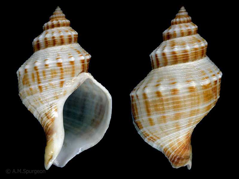
Washed up at Paraparaumu Beach, Wellington. 49mm
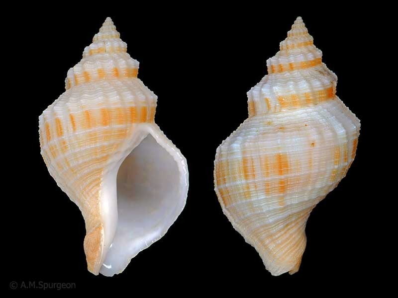
Washed up on beach near Tutukaka, Whangarei. 55mm
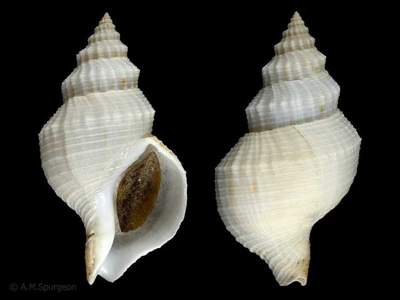
Trawled 70-80 metres, Hanson Bay, Chatham Islands. 61mm
Taxonomy
Family: PROSIPHONIDAE Full Classification: Mollusca (Phylum) > Gastropoda (Class) > Caenogastropoda (Subclass) > Neogastropoda (Order) > Buccinoidea (Superfamily) > Prosiphonidae (Family) > Austrofusus (Genus) > glans (Species) Genus Synonyms: =Aethocola Iredale, 1915 =Austrofusus (Austrofusus) Kobelt, 1879 =Austrofusus (Neocola) Finlay, 1926 Synonymised Names: =Aethocola glans (Röding, 1798) =Austrofusus (Austrofusus) glans (Röding, 1798) =Austrofusus glans agrestior Finlay, 1927 =Austrofusus glans tragulatus Iredale, 1937 =Buccinum nodosum Martyn, 1784 =Buccinum triton Lesson, 1841 =Drupa glans Röding, 1798 =Fusus nodosus Gray, 1843 =Fusus raphanus Lamarck, 1816 =Siphonalia nodosa (Martyn, 1784) |
Details: Austrofusus glans (Röding, 1798)
Size/Grows to:
Height 88mm, Width 41mm
Distribution:
Throughout New Zealand, including Stewart Island
Geographical Range:
ACF
Notes:
Species Links
Distribution Map
References and Publications
- Powell, A.W.B. 1979 New Zealand Mollusca: Marine, Land and Freshwater Shells, Collins, Auckland (p.197)
- Mar/1974 Notes of Interest: Austrofusus glans egg capsules, Poirieria, 7(3) (p.46)
*98 © Museum of New Zealand Te Papa Tongarewa (CC-BY-NC-ND)
Key to Geographical Ranges

The symbols K.A.C.F.M.An. are used to indicate the geographical range of the species.
They have been adopted to give an approximation of the range of each species within New Zealand.
K=
Kermadec Islands
A=
Aupourian - Kaipara Harbour, north around North Cape, encompassing the Three Kings Islands and south to East Cape
C=
Cookian - Lower North Island and the northern part of the South Island
F=
Forsterian - Otago, Fiordland and Stewart Island
M=
Moriorian - Chatham Islands, Pitt Island
An=
Antipodean - Subantarctic Islands of New Zealand
Fw =
Freshwater
L =
Land
N =
North Island
S =
South Island
R =
Recent
Sf =
Subfossil
Fo =
Fossil
Recently Viewed

Compare Species (
/6)