Compare Exilia expeditionis
| toggle to add to compare list |
Taxonomy
Family: PTYCHATRACTIDAE Full Classification: Mollusca (Phylum) > Gastropoda (Class) > Caenogastropoda (Subclass) > Neogastropoda (Order) > Turbinelloidea (Superfamily) > Ptychatractidae (Family) > Exilia (Genus) > expeditionis (Species) Genus Synonyms: =Benthovoluta Kuroda & Habe, 1950 =Chathamidia Dell, 1956 =Daphnella (Surculina) Dall, 1908 =Fasciolaria (Mesorhytis) Meek, 1876 =Graphidula Stephenson, 1941 =Mesorhytis Meek, 1876 =Mitraefusus Bellardi, 1873 =Palaeorhaphis Stewart, 1927 =Phenacoptygma Dall, 1918 =Surculina Dall, 1908 =Zexilia Finlay, 1926 Synonymised Names: =Chathamidia expeditionis Dell, 1956 =Surculina expeditionis (Dell, 1956) |
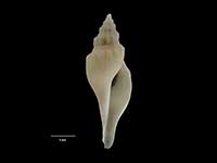
Images: Exilia expeditionis (Dell, 1956)

Holotype, collected 10 Feb 1954, Chatham Rise, NZ (M.009260). © Museum of New Zealand Te Papa Tongarewa (CC-BY-NC-ND)
Taxonomy
Family: PTYCHATRACTIDAE Full Classification: Mollusca (Phylum) > Gastropoda (Class) > Caenogastropoda (Subclass) > Neogastropoda (Order) > Turbinelloidea (Superfamily) > Ptychatractidae (Family) > Exilia (Genus) > expeditionis (Species) Genus Synonyms: =Benthovoluta Kuroda & Habe, 1950 =Chathamidia Dell, 1956 =Daphnella (Surculina) Dall, 1908 =Fasciolaria (Mesorhytis) Meek, 1876 =Graphidula Stephenson, 1941 =Mesorhytis Meek, 1876 =Mitraefusus Bellardi, 1873 =Palaeorhaphis Stewart, 1927 =Phenacoptygma Dall, 1918 =Surculina Dall, 1908 =Zexilia Finlay, 1926 Synonymised Names: =Chathamidia expeditionis Dell, 1956 =Surculina expeditionis (Dell, 1956) |
Details: Exilia expeditionis (Dell, 1956)
Size/Grows to:
Height 42mm, Width 20mm
Distribution:
Trawled off South Island east coast to Chatham Islands, 400-984 metres
Notes:
Species Links
Distribution Map
References and Publications
- Kantor, Y.I., Bouchet, P., Oleinik, A. 2001 A revision of the Recent species of Exilia, formerly Benthovoluta (Gastropoda: Turbinellidae), Ruthenica, 11 (p.127)
- Harasewych, M.G. 1987 A revision of the genus Benthovoluta with notes on the evolution of the subfamily Ptychatractinae (Prosobranchia: Turbinellidae), The Nautilus, 101(4) (p.177)
- Powell, A.W.B. 1979 New Zealand Mollusca: Marine, Land and Freshwater Shells, Collins, Auckland (p.217)
- Dell, R.K. 1956 The archibenthal Mollusca of New Zealand, Dominion Museum Bulletin, 18 (p.118) Original Description
*98 © Museum of New Zealand Te Papa Tongarewa (CC-BY-NC-ND)
NZ Geographical Regions

Key to symbols used in Checklist.
Fw =
Freshwater
L =
Land
N =
North Island
S =
South Island
R =
Recent
Sf =
Subfossil
Fo =
Fossil
Recently Viewed
Compare Species (
/6)