Compare Falsilunatia ambigua
| toggle to add to compare list |
Taxonomy
Family: Subfamily: NATICIDAE: GLOBISININAE Full Classification: Mollusca (Phylum) > Gastropoda (Class) > Caenogastropoda (Subclass) > Littorinimorpha (Order) > Naticoidea (Superfamily) > Naticidae (Family) > Globisininae (Subfamily) > Falsilunatia (Genus) > ambigua (Species) Synonymised Names: =Falsilunatia powelli Dell, 1956 =Polinices ambiguus Suter, 1913 |
Images: Falsilunatia ambigua (Suter, 1913)

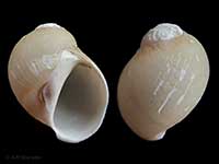
Trawled in 1200 metres, central Chatham Rise, NZ. 11.3mm
Taxonomy
Family: Subfamily: NATICIDAE: GLOBISININAE Full Classification: Mollusca (Phylum) > Gastropoda (Class) > Caenogastropoda (Subclass) > Littorinimorpha (Order) > Naticoidea (Superfamily) > Naticidae (Family) > Globisininae (Subfamily) > Falsilunatia (Genus) > ambigua (Species) Synonymised Names: =Falsilunatia powelli Dell, 1956 =Polinices ambiguus Suter, 1913 |
Details: Falsilunatia ambigua (Suter, 1913)
Size/Grows to:
Height 18mm, Width 16mm
Distribution:
Off Eastern Otago to Chatham Rise, around 400-650 metres
Geographical Range:
CFM
Notes:
Species Links
Distribution Map
References and Publications
- Powell, A.W.B. 1979 New Zealand Mollusca: Marine, Land and Freshwater Shells, Collins, Auckland (p.157)
- Suter, H. 1913 New species of Tertiary Mollusca, Transactions and Proceedings of the New Zealand Institute, 45 (p.294) Original Description
*98 © Museum of New Zealand Te Papa Tongarewa (CC-BY-NC-ND)
Key to Geographical Ranges

The symbols K.A.C.F.M.An. are used to indicate the geographical range of the species.
They have been adopted to give an approximation of the range of each species within New Zealand.
K=
Kermadec Islands
A=
Aupourian - Kaipara Harbour, north around North Cape, encompassing the Three Kings Islands and south to East Cape
C=
Cookian - Lower North Island and the northern part of the South Island
F=
Forsterian - Otago, Fiordland and Stewart Island
M=
Moriorian - Chatham Islands, Pitt Island
An=
Antipodean - Subantarctic Islands of New Zealand
Fw =
Freshwater
L =
Land
N =
North Island
S =
South Island
R =
Recent
Sf =
Subfossil
Fo =
Fossil
Recently Viewed
Compare Species (
/6)