Compare Tugali suteri
| toggle to add to compare list |
Taxonomy
Family: Subfamily: FISSURELLIDAE: EMARGINULINAE Full Classification: Mollusca (Phylum) > Gastropoda (Class) > Vetigastropoda (Subclass) > Lepetelllida (Order) > Fissurelloidea (Superfamily) > Fissurellidae (Family) > Emarginulinae (Subfamily) > Tugali (Genus) > suteri (Species) Genus Synonyms: =Emarginula (Tugali) Gray, 1843 =Subemarginula (Tugalia) Gray, 1843 =Tugalia Gray, 1857 Synonymised Names: =Emarginula (Tugali) suteri Thiele, 1917 =Emarginula suteri Thiele, 1917 =Tugali suteri suteri (Thiele, 1917) accepted, alternate representation =Tugalia bascauda Hedley, 1917 |
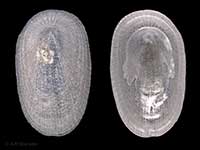
Images: Tugali suteri (Thiele, 1917)

In beach drift, Cape Maria van Diemen, Far North, NZ. 14mm

Collected in 19 metres, Leigh, south of marine reserve, Auckland, NZ (MA116871). © Auckland Museum (CC-BY)
Taxonomy
Family: Subfamily: FISSURELLIDAE: EMARGINULINAE Full Classification: Mollusca (Phylum) > Gastropoda (Class) > Vetigastropoda (Subclass) > Lepetelllida (Order) > Fissurelloidea (Superfamily) > Fissurellidae (Family) > Emarginulinae (Subfamily) > Tugali (Genus) > suteri (Species) Genus Synonyms: =Emarginula (Tugali) Gray, 1843 =Subemarginula (Tugalia) Gray, 1843 =Tugalia Gray, 1857 Synonymised Names: =Emarginula (Tugali) suteri Thiele, 1917 =Emarginula suteri Thiele, 1917 =Tugali suteri suteri (Thiele, 1917) accepted, alternate representation =Tugalia bascauda Hedley, 1917 |
Details: Tugali suteri (Thiele, 1917)
Size/Grows to:
Length 15mm, Width 11mm
Distribution:
North Island, Cook Strait and Chatham Islands
Notes:
Species Links
Distribution Map
References and Publications
- Bracegirdle, S. Nov/2003 Four Limpets - Owhiro Bay, Wellington, Cookia, 15 (p.20)
- Powell, A.W.B. 1979 New Zealand Mollusca: Marine, Land and Freshwater Shells, Collins, Auckland (p.40)
*98 © Museum of New Zealand Te Papa Tongarewa (CC-BY-NC-ND)
NZ Geographical Regions

Key to symbols used in Checklist.
Fw =
Freshwater
L =
Land
N =
North Island
S =
South Island
R =
Recent
Sf =
Subfossil
Fo =
Fossil
Recently Viewed
Compare Species (
/6)