Compare Notoacmea sturnus
| toggle to add to compare list |
Taxonomy
Family: LOTTIIDAE Full Classification: Genus Synonyms: =Conacmea W.R.B. Oliver, 1926 =Notoacmea (Conacmea) W.R.B. Oliver, 1926 =Notoacmea (Notoacmea) Iredale, 1915 =Notoacmea (Parvacmea) Iredale, 1915 =Notoacmea (Subacmea) W.R.B. Oliver, 1926 =Parvacmea Iredale, 1915 =Subacmea W.R.B. Oliver, 1926 =Thalassacmea W.R.B. Oliver, 1926 Synonymised Names: =Notoacmea (Notoacmea) pileopsis sturnus (Hombron & Jacquinot, 1841) =Notoacmea pileopsis sturnus (Hombron & Jacquinot, 1841) =Patella cantharus Reeve, 1855 =Patella sturnus Hombron & Jacquinot, 1841 =Patelloides antarctica Hombron & Jacquinot, 1841 |
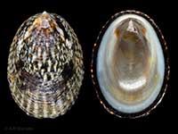
Images: Notoacmea sturnus (Hombron & Jacquinot, 1841)

Ocean Beach, Bluff. 19mm
Taxonomy
Family: LOTTIIDAE Full Classification: Genus Synonyms: =Conacmea W.R.B. Oliver, 1926 =Notoacmea (Conacmea) W.R.B. Oliver, 1926 =Notoacmea (Notoacmea) Iredale, 1915 =Notoacmea (Parvacmea) Iredale, 1915 =Notoacmea (Subacmea) W.R.B. Oliver, 1926 =Parvacmea Iredale, 1915 =Subacmea W.R.B. Oliver, 1926 =Thalassacmea W.R.B. Oliver, 1926 Synonymised Names: =Notoacmea (Notoacmea) pileopsis sturnus (Hombron & Jacquinot, 1841) =Notoacmea pileopsis sturnus (Hombron & Jacquinot, 1841) =Patella cantharus Reeve, 1855 =Patella sturnus Hombron & Jacquinot, 1841 =Patelloides antarctica Hombron & Jacquinot, 1841 |
Details: Notoacmea sturnus (Hombron & Jacquinot, 1841)
Size/Grows to:
Length 31.9mm, Width 23mm, Height 13mm
Distribution:
South Island, from Banks Peninsula south. Snares, Auckland, Campbell, Bounty, Antipodes & Macquarie Islands
Notes:
Species Links
Distribution Map
References and Publications
- Nakano, T., Marshall, B.A., Kennedy, M., Spencer, H.G. 2009 The phylogeny and taxonomy of New Zealand Notoacmea and Patelloida species (Mollusca: Patellogastropoda: Lottiidae) inferred from DNA sequences, Molluscan Research, 29(1) (p.55)
- Powell, A.W.B. 1979 New Zealand Mollusca: Marine, Land and Freshwater Shells, Collins, Auckland (p.47)
*98 © Museum of New Zealand Te Papa Tongarewa (CC-BY-NC-ND)
NZ Geographical Regions

Key to symbols used in Checklist.
Fw =
Freshwater
L =
Land
N =
North Island
S =
South Island
R =
Recent
Sf =
Subfossil
Fo =
Fossil
Recently Viewed
Compare Species (
/6)