Compare Notoplax rubiginosa
| toggle to add to compare list |
Taxonomy
Family: ACANTHOCHITONIDAE Full Classification: Mollusca (Phylum) > Polyplacophora (Class) > Neoloricata (Subclass) > Chitonida (Order) > Acanthochitonina (Suborder) > Cryptoplacoidea (Superfamily) > Acanthochitonidae (Family) > Notoplax (Genus) > rubiginosa (Species) Genus Synonyms: =Acanthochites (Notoplax) H. Adams, 1862 =Acanthochiton (Notoplax) H. Adams, 1862 =Cryptoplax (Notoplax) H. Adams, 1862 Synonymised Names: =Acanthochiton foveauxensis Mestayer, 1926 =Acanthochiton foveauxensis var. kirki Mestayer, 1926 =Chiton rubiginosus Hutton, 1872 =Craspedochiton rubiginosus (Hutton, 1872) =Lophoplax finlayi Ashby, 1926 =Macandrellus oliveri Mestayer, 1926 =Notoplax (Amblyplax) foveauxensis Ashby, 1926 =Notoplax (Amblyplax) oliveri Ashby, 1926 =Tonicia rubiginosa Hutton, 1872 |
Images: Notoplax rubiginosa (Hutton, 1872)
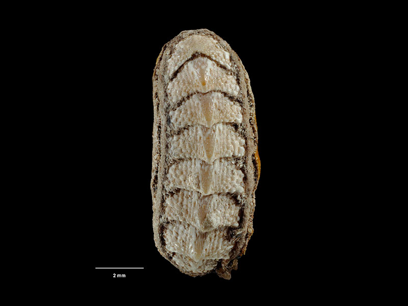
Holotype, collected Kapiti Island, NZ (M.000274). ~12-14mm. © Museum of New Zealand Te Papa Tongarewa (CC-BY-NC-ND)
Taxonomy
Family: ACANTHOCHITONIDAE Full Classification: Mollusca (Phylum) > Polyplacophora (Class) > Neoloricata (Subclass) > Chitonida (Order) > Acanthochitonina (Suborder) > Cryptoplacoidea (Superfamily) > Acanthochitonidae (Family) > Notoplax (Genus) > rubiginosa (Species) Genus Synonyms: =Acanthochites (Notoplax) H. Adams, 1862 =Acanthochiton (Notoplax) H. Adams, 1862 =Cryptoplax (Notoplax) H. Adams, 1862 Synonymised Names: =Acanthochiton foveauxensis Mestayer, 1926 =Acanthochiton foveauxensis var. kirki Mestayer, 1926 =Chiton rubiginosus Hutton, 1872 =Craspedochiton rubiginosus (Hutton, 1872) =Lophoplax finlayi Ashby, 1926 =Macandrellus oliveri Mestayer, 1926 =Notoplax (Amblyplax) foveauxensis Ashby, 1926 =Notoplax (Amblyplax) oliveri Ashby, 1926 =Tonicia rubiginosa Hutton, 1872 |
Details: Notoplax rubiginosa (Hutton, 1872)
Size/Grows to:
Length 18mm, Width 10mm
Distribution:
North, South, Stewart and Chatham Islands. 10-80 metres
Geographical Range:
ACFM
Notes:
Species Links
Distribution Map
References and Publications
- Powell, A.W.B. 1979 New Zealand Mollusca: Marine, Land and Freshwater Shells, Collins, Auckland (p.31)
Key to Geographical Ranges

The symbols K.A.C.F.M.An. are used to indicate the geographical range of the species.
They have been adopted to give an approximation of the range of each species within New Zealand.
K=
Kermadec Islands
A=
Aupourian - Kaipara Harbour, north around North Cape, encompassing the Three Kings Islands and south to East Cape
C=
Cookian - Lower North Island and the northern part of the South Island
F=
Forsterian - Otago, Fiordland and Stewart Island
M=
Moriorian - Chatham Islands, Pitt Island
An=
Antipodean - Subantarctic Islands of New Zealand
Fw =
Freshwater
L =
Land
N =
North Island
S =
South Island
R =
Recent
Sf =
Subfossil
Fo =
Fossil
Recently Viewed
Compare Species (
/6)