Compare Atrina zelandica
| toggle to add to compare list |
Taxonomy
Family: PINNIDAE Full Classification: Genus Synonyms: =Atrina (Atrina) Gray, 1842 accepted, alternate representation =Atrina (Australopinna) P.W. Schultz & M. Huber, 2013 accepted, alternate representation =Atrina (Servatrina) Iredale, 1939 accepted, alternate representation =Pennaria Mörch, 1853 =Servatrina Iredale, 1939 Synonymised Names: =Atrina (Australopinna) zelandica (Gray, 1835) accepted, alternate representation =Pinna senticosa Gould, 1850 =Pinna zelandica Gray, 1835 |
Images: Atrina zelandica (Gray, 1835)
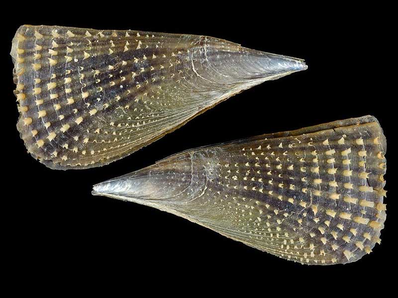
Marlborough Sounds, in Scallop beds. 185mm

Alive below low tide, half buried in sand. Nelson, NZ. 150mm
Taxonomy
Family: PINNIDAE Full Classification: Genus Synonyms: =Atrina (Atrina) Gray, 1842 accepted, alternate representation =Atrina (Australopinna) P.W. Schultz & M. Huber, 2013 accepted, alternate representation =Atrina (Servatrina) Iredale, 1939 accepted, alternate representation =Pennaria Mörch, 1853 =Servatrina Iredale, 1939 Synonymised Names: =Atrina (Australopinna) zelandica (Gray, 1835) accepted, alternate representation =Pinna senticosa Gould, 1850 =Pinna zelandica Gray, 1835 |
Details: Atrina zelandica (Gray, 1835)
Size/Grows to:
Length 300mm, Width 120mm. with records over 440mm
Distribution:
North, South, Stewart and Chatham Islands
Geographical Range:
ACFM
Notes:
Species Links
Distribution Map
References and Publications
- Powell, A.W.B. 1979 New Zealand Mollusca: Marine, Land and Freshwater Shells, Collins, Auckland (p.375)
- Taylor, W. Oct/1974 Notes of Interest: Atrina zelandica, Poirieria, 7(5) (p.101)
Key to Geographical Ranges

The symbols K.A.C.F.M.An. are used to indicate the geographical range of the species.
They have been adopted to give an approximation of the range of each species within New Zealand.
K=
Kermadec Islands
A=
Aupourian - Kaipara Harbour, north around North Cape, encompassing the Three Kings Islands and south to East Cape
C=
Cookian - Lower North Island and the northern part of the South Island
F=
Forsterian - Otago, Fiordland and Stewart Island
M=
Moriorian - Chatham Islands, Pitt Island
An=
Antipodean - Subantarctic Islands of New Zealand
Fw =
Freshwater
L =
Land
N =
North Island
S =
South Island
R =
Recent
Sf =
Subfossil
Fo =
Fossil
Recently Viewed
Compare Species (
/6)