Compare Plaxiphora egregia
| toggle to add to compare list |
Taxonomy
Family: MOPALIIDAE Full Classification: Mollusca (Phylum) > Polyplacophora (Class) > Neoloricata (Subclass) > Chitonida (Order) > Mopalioidea (Superfamily) > Mopaliidae (Family) > Plaxiphora (Genus) > egregia (Species) Genus Synonyms: =Aerilamma Hull, 1924 =Chiton (Plaxiphora) Gray, 1847 =Guildingia Carpenter, 1882 =Diaphoroplax Iredale, 1914 =Maorichiton Iredale, 1914 =Vaferichiton Iredale & Hull, 1932 Synonymised Names: =Acanthochaetes ovatus Hutton, 1872 =Frembleya egregia H. Adams, 1867 =Plaxiphora (Frembleya) egregia (H. Adams, 1867) accepted, alternate representation =Streptochiton tortuosus Pilsbry, 1893 |
Images: Plaxiphora egregia (H.Adams, 1866)
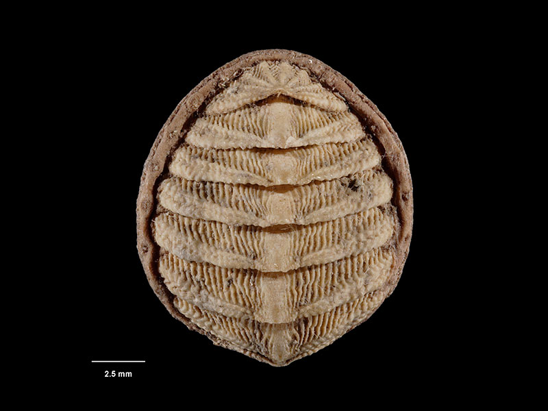
Collected no other data, NZ (M.000277). © Museum of New Zealand Te Papa Tongarewa (CC-BY-NC-ND)
Taxonomy
Family: MOPALIIDAE Full Classification: Mollusca (Phylum) > Polyplacophora (Class) > Neoloricata (Subclass) > Chitonida (Order) > Mopalioidea (Superfamily) > Mopaliidae (Family) > Plaxiphora (Genus) > egregia (Species) Genus Synonyms: =Aerilamma Hull, 1924 =Chiton (Plaxiphora) Gray, 1847 =Guildingia Carpenter, 1882 =Diaphoroplax Iredale, 1914 =Maorichiton Iredale, 1914 =Vaferichiton Iredale & Hull, 1932 Synonymised Names: =Acanthochaetes ovatus Hutton, 1872 =Frembleya egregia H. Adams, 1867 =Plaxiphora (Frembleya) egregia (H. Adams, 1867) accepted, alternate representation =Streptochiton tortuosus Pilsbry, 1893 |
Details: Plaxiphora egregia (H.Adams, 1866)
Size/Grows to:
Length 26mm, Width 18mm
Distribution:
Cook Strait to Stewart Island. Under giant kelp holdfasts
Geographical Range:
CF
Notes:
Species Links
Distribution Map
References and Publications
- Powell, A.W.B. 1979 New Zealand Mollusca: Marine, Land and Freshwater Shells, Collins, Auckland (p.27)
Key to Geographical Ranges

The symbols K.A.C.F.M.An. are used to indicate the geographical range of the species.
They have been adopted to give an approximation of the range of each species within New Zealand.
K=
Kermadec Islands
A=
Aupourian - Kaipara Harbour, north around North Cape, encompassing the Three Kings Islands and south to East Cape
C=
Cookian - Lower North Island and the northern part of the South Island
F=
Forsterian - Otago, Fiordland and Stewart Island
M=
Moriorian - Chatham Islands, Pitt Island
An=
Antipodean - Subantarctic Islands of New Zealand
Fw =
Freshwater
L =
Land
N =
North Island
S =
South Island
R =
Recent
Sf =
Subfossil
Fo =
Fossil
Recently Viewed
Compare Species (
/6)